Cézallier massif
In contrast to the two neighbouring, higher stratovolcanoes, the Monts du Cantal and Monts Dore, where glacial erosion has left sharp ridges and steep cirques in their centers, the Haut Cézallier – although once entirely ice-covered, albeit for less prolonged and less intense periods – features essentially gentle, rounded reliefs (domes, plateaux).
To the north, the last volcanic edifices, not yet dismantled by erosion, also display more vigorous forms (Montchal and Montcineyre eruptive cones, Chamaroux dome).
The highest point of the massif, in one of these woods, is the Signal du Luguet (1,547 metres), close to the village of the same name and overlooking the former Artout glacial cirque.
The Cézallier forms a series of plateaus and small volcanic mountains, mainly made up of fluid lava flows (basalt) but also a few craters, the most recent of which are only a few thousand years old (Montchal, Montcineyre) and are sometimes occupied by lakes (Pavin, Chauvet, La Godivelle).
In its central part, the volcano consists of an accumulation of lava flows (basalt) and fragmented materials associated with trachyte and phonolite domes, as well as layers of pumice.
On the outskirts of the Luguet massif, all that remains of this activity are a few mounds cleared by glacial erosion and then by run-off water (relief inversion process).
The result is a high overall precipitation level and a significant, albeit irregular, winter snowfall due to oceanic thaws and the predominant role played by the wind in the vast pastoral areas (the snow is "swept" by the wind and accumulates massively in snowdrifts on the edges of plateaus and in sheltered valleys, resulting in snowdrifts that generally linger until May or June in the highest parts).
Added to this are local nuances caused by the internal and external layout of the relief:[6] The vegetation reflects the contrasts in climate.
The central and north-western regions, home to verdant estives, heather and bilberry moors, post-glacial peat bogs and beech forests (more rarely fir or spruce plantations) typical of the Atlantic mountains, give way to a drier landscape as you move south and east, home to oaks, Scots pines and pseudo-garrigues.
Wild mammals include marmots, red deer and chamois.The Cézallier's rugged topography is characterized by significant differences in altitude.
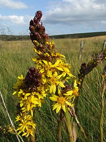
These vast meadows are home to yellow gentian, knapweed, orchids, bluebells, wild pansy, potentilla, mountain arnica, brunelle, bedstraw, martagon lily and pulsatilla anemone.
Beech forests occupy the colder slopes, while the hillsides are covered with moorland, oak coppice and Scots pine.The cool, wet climate of the Cézallier, combined with the relief inherited from volcanism and glacial erosion (sunken basins), has led to the development of numerous peat bogs.
The water temperature can reach 0 °C on certain summer nights, restricting the normal decomposition process of dead plant material (the principle of peat accumulation).
Around the year 1000, the region, far removed from the tutelary power of the Dukes of Aquitaine, was the object of much armed violence due to rivalries between local lords.
These castles consisted of a mound surrounded by ditches, a wooden palisade and a vast central tower, also made of wood (Le Luguet, Chavagnac, Peyrusse).
Local historian Gérard Chevassus has listed their main characteristics: they are square or rectangular in cross-section, with only small openings on the sides.
Also in the 13th century, the remains of a medieval village crossed by three ancient roads were found, as well as vast sheep pens around the present-day burons of Troucou and Villeneuve-bas (Vèze).
In the 17th century, the mountains were attached to estates belonging to noble and middle-class families, and large areas of estives were created.
In 1826, Abbé de Pradt tried to introduce Swiss bulls onto his properties near Pradiers, with the aim of crossing them with Salers females.
[2] From time immemorial, the Cézallier has supplied numerous peddlers who would descend on the "bas pays" to offer their sheets, blankets and various utensils.
[9] The Anzat-le-Luguet antimony mine was discovered in 1814 by Jean d'Auzat Bertier, who was granted a concession on January 10, 1821, by royal decree.
[10] At the same time and on the same site, a concession was granted in 1837 for the Bosberty silver and arsenic mine, located at the ends of the communes of Anzat-le-Luguet and Molèdes, for which a small ore processing plant was built.
In 1956, Fourme du Cantal cheese was awarded the AOC (Appellation d'origine contrôlée) label, but sales continued to decline.
[2] In the early 1960s, the reconquest of highland pastures was once again on the agenda, thanks to the expansion of the livestock market to Italy and the government's policy of supporting beef production.
In 1963, the Coopérative cantalienne de transhumance (COPTASA) was created, bringing together 1,126 hectares of Pradiers and the surrounding area, with the Paillassère-Bas buron overlooking the sources of the Sianne as its technical center.
[2] At the beginning of the 1970s, the average size of private property in the Cézallier was 38 hectares, which still corresponds closely to the area once required for a cow barn.
In 1984, the introduction of milk quotas to reduce surpluses in Europe dealt the final blow to pastoral activity, the burons and the fourme d'estive.
In summer, the mountains are dotted with huge herds of reddish-brown cows characteristic of the Salers breed, as well as the Aubrac, Montbéliarde and Abondancebreeds.
In addition, by order of the Ministers of Ecological Transition and Economy, Finance and Recovery, a permit to explore for high-temperature geothermal deposits covering some 729 km2 (Cantal, Haute-Loire and Puy-de-Dôme) has been granted, until July 22, 2022, to a company.
The power plant will be fed by a production well that will extract geothermal water at a temperature in excess of 150°C from deep, naturally fissured zones.