California State Route 1
Although SR 1 is a popular route for its scenery, frequent landslides and erosion along the coast have caused several segments to be either closed for lengthy periods for repairs, or re-routed inland.
[18] In 1959, the legislature officially designated the segment in Southern California between Interstate 5 (I-5) in Dana Point and US 101 near Oxnard as the Pacific Coast Highway (commonly referred to as "PCH", without the definite article "the", unlike other freeway numbers in the Los Angeles area).
[19] For the most part, SR 1 runs parallel to the coastline, or close to it, but does turn several miles inland at various locations to avoid several federally controlled or protected areas such as Vandenberg Space Force Base, Diablo Canyon Power Plant and Point Reyes National Seashore.
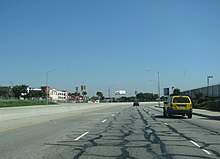
From the traffic circle, it continues inland west through Long Beach, including approximately one mile adjacent to the southern boundary of Signal Hill.
PCH is marked as such in Long Beach, but originally bore the name of Hathaway Avenue east of the traffic circle and State Street west of there.
While bypassing the immediate coastline of Palos Verdes, SR 1 continues to head west into the cities of Lomita and Torrance along the route of the former Redondo-Wilmington Boulevard.
[22][23] After leaving LAX, SR 1 splits from Sepulveda and turns northwest, becoming Lincoln Boulevard and passing through the Los Angeles neighborhoods of Westchester, Playa Vista, and Venice, as well as the unincorporated community of Marina Del Rey.
After passing through a notch in the promontory that marks Point Mugu, the western end of the Santa Monica Mountains, and the beginning of the Oxnard Plain.
[25] After traveling through Ventura, SR 1 separates from US 101 to travel the historic beach route along the Rincon coast that was originally opened up by the construction of the Railroad Coastal Route from Emma Wood State Beach to the Mobil Pier Undercrossing near Sea Cliff, where it rejoins US 101 about 3 miles (4.8 km) south of the Santa Barbara County line near La Conchita.
It is briefly joined with SR 246 along Lompoc's east-west Ocean Avenue, before turning north as H Street to Harris Grade Road, where it then regains the Cabrillo Highway name.
The US 101/SR 1 concurrency then avoids the immediate coastline of Avila Beach and Diablo Canyon Power Plant, and instead heads straight inland to San Luis Obispo.
Shortly thereafter, the highway makes a slight left, becoming the six-lane wide 19th Avenue; the San Francisco Municipal Railway's M Ocean View streetcar line runs in the median from this point until a junction to a rail only right-of-way near Rossmoor Drive.
Then after entering the Presidio of San Francisco, it goes through the MacArthur Tunnel before joining US 101 for a fourth time on the approach to the Golden Gate Bridge known as Doyle Drive.
[22][23] Leaving Tomales Bay, SR 1 heads further inland to intersect with Valley Ford Road just north of the Sonoma County border.
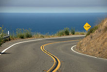
After bridging the Russian River at Jenner, SR 1 continues to wind along the rugged coast to Fort Ross, Salt Point State Parks, and the planned community of Sea Ranch.
[22][23] North of Fort Bragg as a two-lane highway again, SR 1 passes MacKerricher State Park and the towns of Cleone and Inglenook before crossing Ten Mile River.
North of Rockport, the highway turns away from the Lost Coast to avoid steep and unstable highlands created by Mendocino triple junction uplift.
Eager for a direct coastal route between Ventura and Santa Barbara, civic boosters used locally raised funds to begin building the Rincon Sea Level Road in 1911.
[38] The 1921 legislation, in theory, made Route 60 a continuous coastal loop, with both ends at what became US 101 in Oxnard and at Capistrano Beach (since 1964 the southern terminus of SR 1 at Interstate 5 in Orange County).
[43][44] The section of SR 1 from Santa Monica to Oxnard, via Malibu, went out to contract in 1925 as "Coast Boulevard", but was designated "Theodore Roosevelt Highway" when it was dedicated in 1929.
[47] The gaps of non-state highway along the northern coast were finally filled in by the Legislature in 1951, though the State Department of Public Works was not required to maintain the newly added portions immediately.
Plans to upgrade SR 1 to a freeway from its southern terminus all the way to Oxnard, including building an offshore causeway from the Santa Monica Pier to Topanga Canyon Boulevard south of Malibu, were ultimately killed by 1971 due to local opposition.
[53] In 1980, another section was added northwest of Ventura near Emma Wood State Beach, when several miles of the old two-lane alignment of U.S. Route 101 were posted as SR 1 where the freeway had bypassed it in about 1960.
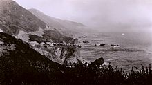
The steepness and related geotechnical challenges of the coastal mountains made this stretch of coastline too costly for highway builders to establish routes through the area.
For the 1932 Summer Olympics, the segment of the SR 1 between Oxnard and Santa Monica (then known as the Theodore Roosevelt Highway) hosted part of the road cycling events.
[89] The Calera Parkway project proposes to widen the non-freeway segment in Pacifica between the Rockaway Beach and Vallemar districts, but is facing opposition by local residents and environmentalists.
Tim Buckley's 1969 album Happy Sad includes a song with the title "Love from Room 109 at the Islander (On Pacific Coast Highway)".
The song reminisces about their early days as a band being flown from Texas out to Los Angeles to be courted by various big record company labels.
In this delightful reimagining, the band ultimately decides it would be easier and more fun to become bank robbers instead, and they make their escape along this famous route ("Let's take The One!").
Described by critics as "introspective", "autumnal", and "hymnlike",[99][100][101] the song takes the perspective of an aged person driving down the highway during sunset as he reflects on his advancing years in life, deciding that he is more comfortable living alone.