Cambridge Bay
The traditional language of the area is Inuinnaqtun and is written using the Latin alphabet rather than the syllabics of the Inuktitut writing system.
[16] The last of the Paleo-Eskimo people, who appeared here about 800 CE, were the Tuniit, and evidence of their living quarters can be seen close to Cambridge Bay.
The Thule people built food caches and stone houses in the area and were noted for their sophisticated tools.
[21][22] The main groups that lived or interacted in the Cambridge Bay area were the Ekalluktogmiut (Iqaluktuurmiutat[23] or Ikaluktuurmiut), Ahiagmiut (Ahiarmiut), the Killinirmuit and the Umingmuktogmiut.
[24] The first Europeans to reach Cambridge Bay were overland Arctic explorers led by Thomas Simpson in 1839; they were searching for the Northwest Passage and had crossed the sea ice on foot.
This was the furthest east any large ship travelled from the Bering Strait until Henry Larsen's west–east sailing of the Northwest Passage aboard St. Roch in 1941.
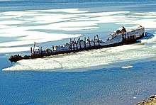
[26][25] In 1925 the HBC purchased the historic ship Maud, which they renamed the Baymaud, from the creditors of Norwegian explorer, Roald Amundsen.
The church, Cambridge Bay's first, was constructed from local material using seal oil and sand as mortar, and was used for services until the 1960s.
[25][29] On 27 April 2006, a large portion of the church, which had been designated a heritage site by the Hamlet Council, was destroyed by a fire which the RCMP said was deliberate.
[25] The military presence and the services and economy this represented acted as a magnet for Inuit who had previously used the area as a temporary site for meeting, hunting, fishing and trade, and a permanent community was soon established across the bay in its current location.
Cambridge Bay is the location of the Canadian High Arctic Research Station (CHARS)[34] campus as announced by Prime Minister Stephen Harper on 24 August 2010.
It will advance Canada's knowledge of the Arctic in order to improve economic opportunities, environmental stewardship, and the quality of life of Northerners and all Canadians.Situated between Dease Strait[38] and Queen Maud Gulf[26] on the southeast coast of Victoria Island (Kitlineq[39]), part of the Arctic Archipelago,[40] Cambridge Bay is a transportation and administrative centre for the Kitikmeot Region.
[41] To the north of the community is Tahiryuaq (also spelt Tahikyoak and formerly Ferguson Lake)[42] which flows into Wellington Bay via the Ekalluk River.
The barren-ground caribou, muskox, Arctic char, lake trout and ringed seal were the primary prey, and remain important food sources.
Autumns are short and crisp, with more frequent cloud cover starting to appear during August and with September being almost constantly cloudy.
[52] Cambridge Bay was chosen after a feasibility study that also included Pond Inlet and Resolute as potential locations.
[66] Prime Minister Harper announced that, starting in 2012, the Government of Canada would spend $142.4 million over a six-year period to build, equip and provision the station.
Additionally, again starting in 2012 and spread over six years, the government would provide $46.2 million for the CHARS Science and Technology Program.
[67] The prime minister stated that to provide for the continuing research and operations $26.5 million per year, beginning in 2018–19, would be made available.
These jobs, which will be full-time, part-time and seasonal, will start in 2017 and run the Science and Technology Program as well as provide the day-to-day operations of the station.
[93] In 2017, the long term residential care unit was opened upstairs at the Kitikmeot Regional Health Centre.
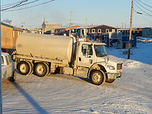
[100][101] Buildings in Cambridge Bay, like in most Nunavut communities, have water and sewage tanks that require regular services by truck.
[111] In 2012, the roads of Cambridge Bay were imaged for Google Street View by a tricycle fitted with a camera system.