Camel's Hump
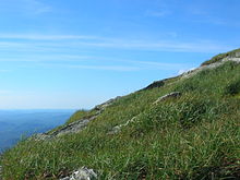
Surmounted by 10 acres (4 ha) of alpine tundra, the mountain is the most significant feature in Camel's Hump State Park.
Isolated from neighboring peaks by the Winooski Valley and glacial action, the mountain's conical silhouette is distinctive, if misleading.
It has two "humps", with the southernmost being the higher, and a steep drop to the south as a result of a quarrying action of the ice passing over it.
[10] Common plants found in this area include: Bigelow's sedge (Carex bigelowii), alpine bilberry (Vaccinium uliginosum), mountain sandwort (Minuartia groenlandica), crowberry (Empetrum nigrum), mountain cranberry (Vaccinium vitis-idaea), and Labrador tea (Rhododendron groenlandicum).
A direct result of glacial formation, these alpine species were once widespread but as the lower elevations warmed, only the very peak of Camel's Hump remained hospitable to the fragile plants.
[14] Of these, five species are protected by the Vermont endangered and threatened species rule:[15] Boott's rattlesnake-root (Nabalus boottii, generically known as white lettuce), bearberry willow (Salix uva-ursi), lesser wintergreen (Pyrola minor), alpine sweetgrass (Anthoxanthum monticola), and squashberry (Viburnum edule).
[16] Despite extensive logging during the late 1800s and a great fire in 1903, Camel's Hump continues to support a significant population of red spruce (Picea rubens).
Starting in the 1960s, Hub Vogelmann and his graduate students from the University of Vermont observed an extensive decline in the red spruce population on the west slope of Camel's Hump.
Vogelmann's 1982 landmark paper “Catastrophe on Camel’s Hump” identified the cause of the decline to be acid rain.
[17][18] Similarly the Forest Decline Project at the University of Vermont published a study in 1991 that again cited acid rain as the culprit.
[19] These findings raised public awareness and eventually led to a revision of the Clean Air Act.
By 2017, with mounting evidence that the health of red spruce was on the rise,[20][21] the scourge of acid rain in the northeast had largely come to an end.
"[22] In 1905, publisher and philanthropist Joseph Battell donated 1,200 acres (4.9 km2) of virgin forest, including the summit of Camel's Hump, to the State of Vermont.
Since then, Vermont has adopted new legislation to preserve its natural areas and in 1969 created a Forest Reserve enclosing the mountain.
Camel's Hump State Park has grown since the original bequest and in 1991 totalled approximately 20,000 acres (81 km2).
[6] In October 1944, during World War II, a B-24J bomber on a training mission crashed into the side of the mountain near the summit.
The GMC now trains and pays a caretaker to reside near the summit during the summer and educate hikers to respect the fragile alpine ecosystem that exists on the mountain.
While many other options were considered, including covered bridges and the snowflake photographs of Wilson Bentley, the seven-person panel ultimately decided on Camel's Hump stating that it was "perfect for the quarter."
"With the only undeveloped alpine area in the Green Mountain State and a skyline that sets it apart from everything else, Camel's Hump may be Vermont's finest peak," says Michael Lanza in his guidebook for New England hiking enthusiasts.
It is named for Will Monroe, who cut the Long Trail from Camel's Hump south to Middlebury Gap beginning in 1916.
The Alpine Trail traverses the site of a plane crash that occurred on Camel's Hump in October 1944.