Cameroon line
The Cameroon line (French: Ligne du Cameroun, Portuguese: Linha dos Camarões, Spanish: cordillera de Camerún) is a 1,600 km (1,000 mi) long chain of volcanoes that includes islands in the Gulf of Guinea and mountains on the African mainland, from Mount Cameroon on the coast towards Lake Chad on the northeast.
The mainland mountain regions are much cooler than the surrounding lowlands, and also contain unique and ecologically important environments.
[1][2] In the Gulf of Guinea, the Cameroon line consists of six offshore volcanic swells that have formed islands or seamounts.
On the mainland, the line starts with Mount Cameroon and extends northeast in a range known as the Western High Plateau, home to the Cameroonian Highlands forests.
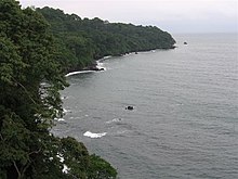
[4] Annobón has lush valleys and steep mountains, covered with rich woods and luxuriant vegetation.
By contrast, the lush south and west of the island receive about 6 m (20 ft) of rain, mostly falling in March and April.
Agriculture is important near the north and east coasts, with the chief exports being cocoa, coffee, copra, and palm products.
Volcanic activity stopped around 15.7 million years ago, and the island has been deeply eroded apart from spectacular towers of phonolite.
It rises in the south to 946 m (3,104 ft) at Pico de Príncipe, in a thickly forested area within the Obo National Park.
As with São Tomé, the island has always been isolated from the mainland and therefore has many unique species of plants and animals, including six endemic birds.
San Carlos is 2,260 m (7,410 ft) high with a broad summit caldera, lying at the extreme SW of the island.
Bioko has exceptional numbers of endemic species of flora and fauna, partly due to the great range of altitudes, particularly birdlife.
[24] The 4,095 m (13,435 ft) Mount Cameroon on the coastline, which may have been observed by the Carthaginian Hanno the Navigator in the 5th century BC, erupted in 2000.
[25] Further inland, the stratovolcano Mount Oku at 3,011 metres (9,879 ft) is the second highest mountain in sub-Saharan mainland West Africa.
During the wet season, humid, prevailing monsoon winds blow in from the west and lose their moisture upon hitting the region's mountains.
The coastline roughly corresponds to the coast of the Borborema geological province of northeastern Brazil, which began to separate from this part Africa around 115 million years ago.
It is visible in the Foumban Shear Zone, which was active before and during the opening of the South Atlantic in the Cretaceous period.
The Benue Trough was formed by rifting of the central West African basement, beginning at the start of the Cretaceous era.
A common explanation of the trough's formation is that it is an aulacogen, an abandoned arm of a three-armed radial rift system.
[41] During the Santonian age, around 84 million years ago, the Benue Trough underwent intense compression and folding.
[44][45] One plume-related hypothesis for the later development of the Cameroon Line around 30 Ma is that it coincides with development of a shallow mantle convection system centered on the mantle plume, and is related to thinning and extension of the crust along the Cameroon line as pressures relaxed in the now stationary plate.
[2] One explanation for the origin of the volcanic line is likely leakage of magma from reactivated Precambrian faults,[46] while another scenario is the rising of mantle material from African Large low-shear-velocity provinces travels under Congo Craton and through existing fractures ultimately feed the volcanic activities.
[47] The puzzling feature, that the composition of the magmas is the same both in the land volcanoes and the oceanic ones is likely explained by recent studies that show the underlying lithosphere is the same.
A gravity study of the southern part of the Adamawa plateau has shown a belt of dense rocks at an average depth of 8 km running parallel to the Foumban shear zone.
The material appears to be an igneous intrusion that may have accompanied reactivation of the shear zone, and may be associated with the Cameroon line.