Camulodunum
[4] Originally the site of the Brythonic-Celtic oppidum of Camulodunon (meaning "stronghold of Camulos"), capital of the Trinovantes and later the Catuvellauni tribes, it was first mentioned by name on coinage minted by the chieftain Tasciovanus some time between 20 and 10 BC.
[9] In the second century AD Ptolemy in his famous treatise Geographia named the base of the Sixth Legion (who governed the Brigantes) a Northern Roman Britain tribe as being near Eboracum (which would eventually become York).
[13] Its Celtic name, Camulodunon, variously represented as CA, CAM, CAMV, CAMVL and CAMVLODVNO on the coins of Cunobelinus, means 'the fortress of [the war god] Camulos'.
[5] Camulodunon is sometimes popularly considered one of many possible sites around Britain for the legendary (perhaps mythical) Camelot of King Arthur,[15] though the name Camelot (first mentioned by the 12th century French Arthurian storyteller Chrétien de Troyes) is most likely a corruption of Camlann, a now unknown location first mentioned in the 10th century Welsh annalistic text Annales Cambriae, identified as the place where Arthur was slain in battle.
[5] The Sheepen site, located around what is now St Helena School on the banks of the River Colne, was a large industrial and port zone, where extensive iron and leather working activity was carried out,[5][18][20] as well as an important coin mint.
Strabo reports Rome's lucrative trade with Britain; the island's exports included grain, gold, silver, iron, hides, slaves and hunting dogs.
[33] Aulus Plautius led the four Roman legions across to Britain with Camulodunon being their main target,[2] defeating and killing Togodumnus near the Thames and then waiting for Claudius to cross the Channel.
[5] Archaeological excavations in 2008–2009 revealed that the Roman Sheepen site was more extensive than previously thought, and had a network of gravelled roads and timber-buildings, some of which contained timber-lined basements.
[5] Tacitus wrote that the town was "a strong colonia of ex-soldiers established on conquered territory, to provide a protection against rebels and a centre for instructing the provincials in the procedures of the law".
[47] A relief army consisting of the Legio IX Hispana led by Quintus Petillius Cerialis attempted to rescue the besieged citizens, but was destroyed outside of the town.
After the Romans under governor Gaius Suetonius Paullinus finally defeated the uprising, the Procurator of the province moved his seat to the newly established commercial settlement of Londinium (London).
[37][38][49] During excavations in 2014 at Williams and Griffin on the High Street a collection of gold and silver jewellery was discovered buried in the floor of a Roman building destroyed during the revolt.
[50] The layer is important to historians as it is one of the first archaeological contexts in Britain that can be given a definitive date, as well as to archaeologists as it provides a snapshot of artifacts from 60, allowing typologies of finds to be tied into a historical timeline, for example in Samian production.
[5] The colonia became a large industrial centre, and was the largest, and for a short time the only, place in the province of Britannia where samian ware was produced, along with glasswork and metalwork, and a coin mint.
[5][53] The colonia is mentioned by name several times by contemporaries, including in Pliny's Natural History, Ptolemy's Geography, Tacitus' Annales, The Antonine Itinerary and the Ravenna Cosmography.
Of the two provincial administrators the senatorial military governor was always located in areas of conflict,[54] whilst the civilian Procurator's office had moved from Camulodunum to the new port of Londinium sometime around the Boudican Revolt.
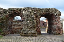
It has a large fortified barbican that still stands as Britain's largest Roman gateway, which incorporated the earlier monumental arch built before the Iceni rebellion and was flanked by two possible temples,[38] one of which may have contained the Venus statuette found during the 1973–76 excavations.
[5] At the centre of this arcade stood the entranceway to the temple precinct, which took the form of a tufa-faced monumental arch that at 8 m wide was about 2 m wider than the one at the Eastern entrance to the town, which had been incorporated into Balkerne Gate.
[5] To the west of the temple on the modern Maidenburgh Street was a 3,000 seat capacity Roman theatre, which now has the Norman chapel of St Helena built into the corner of it,[3] currently open to public viewing.
[76] Camulodunum was a centre for pottery production, peaking at around 200,[70] and over 40 kilns have been in the town, including those found in the northern suburbs of the colonia around Middleborough[38] and a large group at Warren Fields and Oak Drive on the southern outskirts of the Sheepen site.
It was 8 ft wide, with a 5m flue under a large circular kiln chamber, and had a complex system of ceramic pipes and tubes for regulating the oxidisation of the pottery to produce its distinctive red colour.
[5] Oysters from the Colne Estuary and Mersea Island have been an important food source throughout much of Colchester's history, and large dumps (some 0.5m thick) of oyster shells have been found at Balkerne Hill from the Roman period,[5][38] along with mussels, whelks, cockles, carpet shells, winkle and scallop; fish imported from the River Colne and coast are represented by herring, plaice, flounder, eel, smelt, cod, haddock, gurnard, mullet, dragonet, dab, and sole.
[25] Small numbers of tiles were imported from Eccles in Kent by Roman settlements in South-East Britain, including Camulodunum, for a brief time in the First Century, as was Kentish Ragstone for building.
[85] The Temple of Claudius, which underwent large-scale structural additions in the 4th century, may also have been repurposed as a Christian church, as a Chi Rho symbol carved on a piece of Roman pottery found in the vicinity of the temenos.
[5] Further Roman Christian objects found in the town include a candlestick from Balkerne Lane inscribed with an Iota Chi symbol and a bronze spoon with AETERNVS VITA written on it.
[5] A skeleton of a young woman found stretched out on a Roman mosaic floor at Beryfield, within the SE corner of the walled town, was initially interpreted as a victim of a Saxon attack on the Sub-Roman town; however, it is now believed that the burial is a post-Roman grave cut down to the hard floor surface (the name Beryfield means "burial field", a reference to the Medieval graveyards in the area).
[90][91] Archaeology aside, Colchester first explicitly re-enters the written historical record again in the Anglo-Saxon Chronicle for 917, the year it was retaken from the Danes by a Saxon army led by King Edward the Elder, who "restored" the borough to English rule.
[5][65] In 2014 the discovery of marble pillars belonging to the Monumental Facade of the Temple precinct was made behind the High Street, with evidence suggesting that they were still standing until the Castle-builders knocked them over to make way for the Castle Bailey.
According to the Medieval legend,[5] which garbles folk-tales and pseudo-historical events together, he was supposedly the father of St Helena, who was married off to Constantius in a bid to get the latter to lift his two-year siege of the town.
St Helena is today the patron saint of Colchester, and the town's coat of arms depict the True Cross and crowns of the Three Kings that she is supposed to have found in Jerusalem.