Canadian Rockies
It is the easternmost part of the Canadian Cordillera, which is the northern segment of the North American Cordillera, the expansive system of interconnected mountain ranges between the Interior Plains and the Pacific Coast that runs northwest–southeast from central Alaska to the Isthmus of Tehuantepec in Mexico.
[3] The Canadian Rockies, being the northern segment of this chain, is thus defined as comprising the central-eastern section of the North American Cordillera, between the Prairies of Alberta and the Liard Plain of northeastern British Columbia to the east and the Interior Mountains/Plateau and Columbia Mountains to the west.
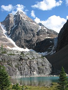
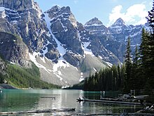
Much of the range is protected by national and provincial parks, several of which collectively comprise a World Heritage Site.
They form part of the American Cordillera, an essentially continuous sequence of mountain ranges that runs all the way from Alaska to the very tip of South America.
Contrary to popular misconception, the Rockies do not extend north into Yukon or Alaska, or west into central British Columbia.
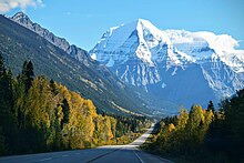
Mount Columbia (3,747 m; 12,293 ft) is the second-highest peak in the Canadian Rockies, and is the highest mountain in Alberta.
The Canadian Rockies are cooler and wetter, giving them moister soil, bigger rivers, and more glaciers.
Waterton Lakes lies farther south, straddling the Canada–US border as the Canadian part of the Waterton-Glacier International Peace Park.
The main difficulty in providing such a link were the Rockies themselves: treacherous mountain passes, fast rivers and sheer drops made for a difficult railway construction process.