Canal du Midi
Jean-Baptiste Colbert authorized the start of work by royal edict in October 1666, with the aim of developing the wheat trade, under the supervision of Pierre-Paul Riquet, and construction lasted from 1666 to 1681, during the reign of Louis XIV.
The key challenge, raised by Pierre-Paul Riquet, was to convey water from the Montagne Noire (Black Mountains) to the Seuil de Naurouze, the highest point of the canal.
[5] This longitudinal profile of the Canal du Midi shows it rising from Toulouse (1) to the Seuil de Naurouze (2), then dropping down to Castelnaudary (3), Carcassonne (4) and Trèbes (5).
Under Article L. 2111-11 of the Code, public domain of the canal is determined by reference to the fief once granted to Pierre-Paul Riquet and limits were set by an official report in 1772.
Articles L. 2124-20 to L. 2124-25 set rules for maintenance of the canal, which is generally the responsibility of the public entity that owns it, with the participation of communes and, in some cases, waterside residents.
King François I brought Leonardo da Vinci to France in 1516 and commissioned a survey of a route from the Garonne at Toulouse to the Aude at Carcassonne.
A first draft was presented by Nicolas Bachelier in 1539 to the Estates of Languedoc[11] then a second in 1598 by Pierre Reneau[12] and finally a third project was proposed by Bernard Aribat de Béziers in 1617.
It is on the design of a canal that could be done in the province of Languedoc for communication between the two seas Océane and Mediterranean, you will be surprised, my lord, that I undertake to tell you about something apparently I do not know and that a collector of salt tax mixes with levelling ...
However, my Lord, please take the trouble to read my mail, so that you may truly judge that this canal is feasible, it is truly difficult because of the cost but it can be seen that the good that will come outweighs the consideration of expense.
You have for that a thousand means, my Lord, and I present to you again two of my memoires attached to help you to consider more that the ease and assurance of this new navigation will make the Straits of Gibraltar cease to be an absolutely necessary passage, that the income of the king of Spain in Cadiz will be reduced and those of our King will rise especially on farms inputs and outputs of goods in this kingdom, in addition the rights received from the said canal will rise to immense sums, and that His Majesty's subjects in general will benefit from a thousand new businesses and will greatly benefit from this navigation, that if I learn that this plan should please you, I will send to you with the number of locks that need to be done and an exact calculation of toises of the said canal, both in length and width.
[19] Thirty years passed from the start of planning to the commencement of work: a similar project was also studied by a committee of which Riquet's father was a member.
In 1663 Riquet conducted field studies to finally fix the path on the Atlantic side by the seuil de Naurouze along the valley of the Hers-Vif to Toulouse downstream of the Garonne.
In addition, to overcome his technical shortcomings, he was surrounded by many technicians such as Hector Boutheroüe, François Andreossy surveyor and cartographer, and Pierre Campmas an expert in water flows.
Thus, the construction of the canal would permit the creation of a direct passage between the Mediterranean Sea and the Atlantic without passing through the Strait of Gibraltar controlled by the Spaniards, the aim being to destroy the Spanish trade and establish a commercial flow through Languedoc.
The Languedoc region had many resources such as wheat, wine from Minervois, woollen cloth, silk, and salt which producers were struggling to export due to lack of trade.
[34] Despite a project that seemed precarious, Colbert authorized commencement of work by a royal edict in October 1666[35] after the approval of a committee of experts that looked at the route of the canal for several months.
Some of Clerville's men with experience in military engineering came, to build the huge dam for the single reservoir, the Bassin de St. Ferréol, on the river Laudot.
To work around the problem, Riquet set up a system of valves and chambers for Libron and a round lock with three doors for the étang de Thau and the Hérault.
The Canal du Midi as a grand piece of infrastructural engineering in itself was promoted as worthy of Rome and the political dreams behind it were clarified with plaques in Latin, and walls built with Roman features.
Building a navigational canal across the continent was well beyond the formal knowledge of the military engineers expected to supervise it, but the peasant women who were carriers of classical hydraulic methods added to the repertoire of available techniques.
[53] The king appointed a commission composed of Henri d'Aguessau, steward of Languedoc, Mr de la Feuille, Father Mourgues a Jesuit professor of rhetoric and mathematics at the University of Toulouse, two sons and two in-laws of Pierre-Paul Riquet, as well as Messrs. Andréossy, Gilade, and Contigny.
Finally, in 1857 the Canal latéral à la Garonne was opened between Toulouse and Castets-en-Dorthe, completing the link between the Atlantic Ocean and the Mediterranean Sea that Riquet had dreamt of.
The Riquet family quickly put up a pyramidal organisation structure with a "Director-General of the Canal" who governs a board of directors responsible for specific geographic areas of the channel.
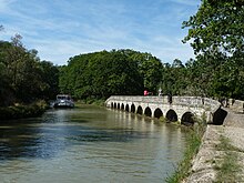
[75] The Canal du Midi also allows other sports, mainly in urban areas, such as rowing, canoeing, fishing, cycling, roller-skating, and hiking along the banks.
[76] The Rigole de la plaine carries water from the Sor tapped from an offtake at Pont Crouzet for irrigation before emptying into the Canal du Midi.
Platanus (plane trees) is a particular source of problems because their roots destroy the banks and the paved cycle paths and their leaves invade the canal.
The classification as a World Heritage Site creates an additional level of oversight by the State who must ensure that any changes along the canal and its structures are compatible with the strategic issues of UNESCO.
The idea was to capture the waters of the Montagne Noire located several tens of kilometres away and bring it to the Seuil de Naurouze, the highest point of the future canal, through channels.
Newer ports were built such as Ramonville-Saint-Agne, called Port-Sud, which has many residential barges and is set directly overlooking the harbour, and Port-Lauragais located near Avignonet-Lauragais on a service area of the A61 autoroute.
[103] In 15 to 20 years all 42,000 plane trees of the Canal du Midi will have to be felled and replaced mainly by other species (ash, lime), after initial experiments with a variety of plane-tree resisting the parasite.