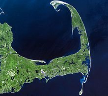
Cape Cod
No longer in "official" use over the ensuing decades, the name came to mean all of the land east of the Manomet and Scusset rivers – essentially along the line that became the Cape Cod Canal.
[10] Its elevation ranges from 306 feet (93 m) at its highest point, at the top of Pine Hill, in the Bourne portion of Joint Base Cape Cod, down to sea level.
Barnstable, the most populated municipality on Cape Cod, is the only one to have adopted a city form of government, whose legislative body is an elected 13-member council.
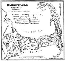
For most of the 18th, 19th, and 20th centuries, Cape Cod was considered to consist of three sections (see map): "East of America, there stands in the open Atlantic the last fragment of an ancient and vanished land.
The bulk of the land on Cape Cod consists of glacial landforms, formed by terminal moraine and outwash plains.
[18]: 28 Using radiocarbon dating techniques, researchers have determined that around 23,000 years ago, the ice sheet reached its maximum southward advance over North America, and then started to retreat.
Many kettle ponds – clear, cold lakes – were formed and remain on Cape Cod as a result of the receding glacier.
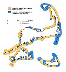
By 6,000 years ago, the sea level was high enough to start eroding the glacial deposits that the vanished continental ice sheet had left on Cape Cod.
The entire town of Provincetown, at the extreme tip of the Cape, is a spit consisting largely of deposited marine sediment that was eroded and transported from farther south along the shore.
[22] In 2023, the state began a nitrogen pollution regulation scheme for Cape Cod and the Islands to address overgrowth of algae, cyanobacteria, and plants.
[24] Consequently, many subtropical indicator plant species typically found in more southerly latitudes are grown there, including Camellias, Ilex opaca, Magnolia grandiflora and Albizia julibrissin.
The February 2013 nor'easter produced winds in excess of 80 miles per hour (130 km/h) and dropped over 24 inches (61 cm) of snow on some parts of Cape Cod.
The documentary Natives of the Narrowland (1993), narrated by actress Julie Harris, shows the history of the Wampanoag people through Cape Cod archaeological sites.
The Manomet River area (taken up by the western end of the Cape Cod Canal in the early 20th century) is claimed by some to have been visited by Leif Eiriksson,[30] and a stone wall[31] discovered in Provincetown in 1805 is also claimed to have been built by his younger brother Thorvald Eiriksson around AD 1007,[32] when the keel of his ship was repaired in the harbor, according to Norse sagas.
[33] However, there is no tangible support of the presence of Norse voyagers in Cape Cod,[34] and the view is not generally accepted by archaeologists or historians.
[38] In 1602, Bartholomew Gosnold named the tip Cape Cod, the surviving term and the ninth oldest English place-name in the U.S.[2] Samuel de Champlain charted its sand-silted harbors in 1606, and Henry Hudson landed there in 1609.
Captain John Smith noted it on his map of 1614, and at last the Pilgrims entered the "Cape Harbor" and made their first landing near Provincetown[citation needed] on November 11, 1620.
Farmers grazed their cattle on the grassy dunes of coastal Massachusetts, only to watch "in horror as the denuded sands 'walked' over richer lands, burying cultivated fields and fences."
The early Industrial Revolution occurred through much of Massachusetts and Rhode Island, but it mostly bypassed Cape Cod due to a lack of significant waterpower in the area.
In 1961, a significant portion of this coastline, already slated for housing subdivisions, was made a part of the Cape Cod National Seashore by President John F. Kennedy.
Other notable residents of Cape Cod have included actress Julie Harris, US Supreme Court justice Louis Brandeis, figure skater Todd Eldredge, composer and radio personality Canary Burton, and novelists Norman Mailer and Kurt Vonnegut.
Many of Cape Cod's earliest lighthouses featured a light tower that was attached directly to – and centered on the roof of – the keeper's dwelling.
The service is primarily tourist-oriented and includes a dinner train over a scenic route between Hyannis and the Cape Cod Canal lasting about 21⁄2 hours round trip.
Additional service is also provided from the Buzzards Bay station, and a small number of trains also depart from North Falmouth.
Active freight service remains in the Upper Cape, both along the main line from Bourne to Hyannis and on the spur to North Falmouth.
One of the more frequent operations is the transport of municipal waste to a waste-to-energy plant in Rochester, as well as the removal of debris and refuse from Joint Base Cape Cod in Falmouth.
In the late 20th century, tourists and owners of second homes began visiting the Cape more and more in the spring and fall, softening the definition of the high season and expanding it somewhat.
Each summer, the Naukabout Music Festival is held at the Barnstable County Fair Grounds located in East Falmouth, typically during the first weekend of August.
Among the species most widely pursued are striped bass, bluefish, bluefin tuna, false albacore (little tunny), bonito, tautog, flounder and fluke.
[50] The current teams in the league are the Bourne Braves, Brewster Whitecaps, Chatham Anglers (formerly the Chatham Athletics), Cotuit Kettleers, Falmouth Commodores, Harwich Mariners, Hyannis Harbor Hawks (formerly the Hyannis Mets), Orleans Firebirds (formerly the Orleans Cardinals), Wareham Gatemen and the Yarmouth–Dennis Red Sox.