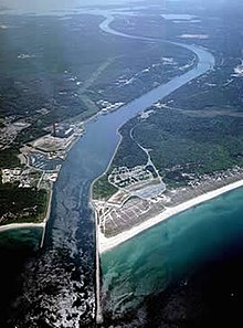
Cape Cod Canal
Scusset Beach State Reservation lies near the canal's north entrance, and the Massachusetts Maritime Academy is near its south.
[5][6] Construction of a canal was first considered by Myles Standish of the Plymouth Colony in 1623, and the Pilgrims scouted the low-lying stretch of land between the Manomet[a] and Scusset rivers for potential routes.
Trade prospered with the Indians of Narragansett Bay and the Dutch of New Netherland, and this was a major factor enabling the Pilgrims to pay off their debt.
[9] In 1717, a canal was created in Orleans, Massachusetts called Jeremiah's Gutter which spanned a narrower portion of the Cape some distance to the east, but it remained active only until the late 1800s.
[citation needed] The first attempts at actually building a canal did not take place until the late 19th century; earlier planners either ran out of money or were overwhelmed by the project's size.
The first excavation began in 1880, when the Cape Cod Ship Canal Company hired 400 immigrant Italian laborers to begin digging with shovels and wheelbarrows.
[15] Several accidents occurred due to the narrow channel and navigation difficulty, and these limited traffic and tarnished the canal's reputation.
Toll revenues failed to meet investors' expectations as a result, despite shortening the trade route from New York City to Boston by 62 miles (100 km).
Four days earlier, the German U-boat U-156 surfaced three miles (5 km) off Orleans, Massachusetts on July 21, 1918, and shelled the tugboat Perth Amboy and her string of four barges.
The canal remained under government control until 1920, during which the United States Army Corps of Engineers re-dredged the channel to 25 feet (7.6 m) deep.
A 0.7-mile (1.1 km) trail there leads to Sagamore Hill, once an Indian meeting ground and the site of a World War II coastal fortification.
[23] Bournedale Hills Trail extends 1.4 miles (2.3 km) along the north side of the Canal from Bourne Scenic Park campground to the Herring Run.