Cape Spear
[1] Cape Spear is within the municipal boundaries of the city of St. John's, located about 12 kilometres (7.5 mi) from downtown St.
][5][6] harvesting subsistence resources on a temporary basis prior to permanent residency at settlements such as St. George's Bay and Conne River from the nineteenth century onwards.
[5] According to Fife and Roseman, historically there are "no indications that either the Beothuk or the Mi'kmaq equated Cape Spear with a 'land's end' that was meaningful to them.
Cape Spear was chosen as the site for a new lighthouse because it was on the rocky eastern coast near the entrance to St. John's harbor.
Nicholas Croke and William Parker, two St. John's builders, won the contract for the lighthouse and work began in 1834 or early in 1835.
[13] Some visitors attracted by the scenery and history have been swept away by the large and unpredictable waves at Cape Spear, prompting Parks Canada to post numerous warning signs in the area.
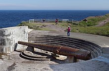
[14][15] It was built during World War II and responsible for monitoring air traffic from RCAF Torbay and into the Atlantic Ocean.
[20] The site was established in 1942 as a United States Ground Radar Early Warning Station, funded by the United States Army,[21] which stationed the 685th Air Warning Company on the site under operational control of Newfoundland Base Command at Pepperrell Air Force Base.
[25] Units: Assignments: This article incorporates public domain material from the Air Force Historical Research Agency