Capital Beltway
This circumferential roadway, which is located mostly in Maryland and Virginia, also has a 0.11-mile (0.18 km) section through the District of Columbia, near the western end of the Woodrow Wilson Bridge over the Potomac River.
The route descriptions below follow the direction of the Outer Loop, starting at the Woodrow Wilson Bridge over the Potomac River, south of Washington.
However, environmental litigation stopped the completion of this plan, and the built portion of I-95 inside the beltway from the south northward into Downtown was redesignated I-395 in 1977.
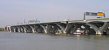
The beltway—here I-95 and I-495 together and four lanes in each direction—travels over the tidal Potomac River on the Woodrow Wilson Bridge between Alexandria, Virginia, and the neighborhood of National Harbor of Oxon Hill, Maryland.
The Federal Highway Administration (FHWA) recognizes 0.11 miles (0.18 km) of the bridge as crossing the tip of the southernmost corner of the District of Columbia,[3] but, while there are signs acknowledging the Maryland and Virginia state borders, there are none for DC.
The highway passes south of Oxon Cove Park and Oxon Hill Farm and next intersects Maryland Route 210 (MD 210; Indian Head Highway), a major north–south route from southern DC to Indian Head in Charles County, which also serves the town of Forest Heights to the north at another interconnected interchange.
The beltway then interchanges with US 50/unsigned I-595, a major highway from Downtown eastward to Annapolis and the Chesapeake Bay Bridge to the Eastern Shore of Maryland.
Continuing west from the College Park Interchange, I-495 crosses into Montgomery County, entering a heavily developed and populated area.
[a] The route twists along the alignment, through and around Rock Creek Park, then interchanges with MD 185 near the Walter Reed National Military Medical Center.
Instead, Outer Loop traffic must use the eastbound Dulles Access Road exit three miles (4.8 km) to the north in order to reach I-66 east.
Continuing east, the two routes encounter US 1, a major north–south highway providing access to Alexandria, Arlington, and Downtown, as well as various points south in Fairfax County.
Finally, beyond this complex interchange, I-95 and I-495 together cross Alexandria's Jones Point Park and exit Virginia via the Woodrow Wilson Bridge.
[5] Backed by Senator Francis H. Case of South Dakota, the plan called for the highway to begin in Beltsville at the nearly completed B–W Parkway, continue west through Silver Spring and Bethesda, cross the Potomac River over a new bridge, head south near Tysons Corner and Falls Church, turn east by the Shirley Memorial Highway, and end at US 1 in Gum Springs.
[5] The federal government gave final approval for the construction of the Capital Beltway (also known as the Circumferential Highway in the planning stages) on September 28, 1955.
The first section of the 64-mile-long (103 km) beltway (including the Woodrow Wilson Bridge over the Potomac River) was opened on December 21, 1961; the highway was completed on August 17, 1964.
Originally designated I-495, in 1977, the eastern portion of the beltway was redesignated I-95 when a proposed alignment of I-95 from New York Avenue in Washington, D.C., through Prince George's County, Maryland, to I-495 was canceled.
This parlance too has led to its own confusion, with unfamiliar motorists imagining two separate, distinct highway alignments, one some distance inside the other.
The beltway was originally envisioned as primarily a bypass for long-distance eastern seaboard traffic to avoid driving directly through Washington, D.C.
The newer Fairfax County Parkway in the 1990s helped ease some traffic on the Virginia beltway; however, various proposals to build another complete outer beltway in the outer suburbs has not gotten off the ground because local governments in Maryland object to building additional Potomac River crossings as well as destroying protected "open space" and creating sprawl.
The Woodrow Wilson Bridge—where eight lanes were squeezed into six—was particularly onerous, with miles-long backups daily during commuter rush hours and on heavily traveled weekends.
In April 2005, the Virginia Department of Transportation (VDOT) signed an agreement with two private companies to build high-occupancy toll (HOT) lanes on the stretch of the beltway between Springfield and Georgetown Pike.
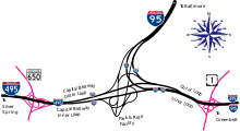
As a result, north–south traffic between I-295 and Indian Head Highway was forced to merge onto a congested section of the beltway for approximately one mile (1.6 km).
However, these interchanges were redesigned and rebuilt to accommodate the expansion of the Woodrow Wilson Bridge and the construction of dedicated ramps to National Harbor.
The eight-year, nearly $676-million (equivalent to $957 million in 2023[15]) project worked to eliminate weaving among local and long-distance traffic between I-95, I-395, the beltway, and SR 644.
The Woodrow Wilson Bridge underwent reconstruction in a major project that began in 1999; it now provides express and local lanes for both the Inner and Outer loops.
Drivers using the HOT lanes are required to carry an E-ZPass transponder to allow electronic toll collection, eliminating the need for tollbooths.
[17] Tolls are waived for buses, carpools of at least three people, motorcycles, and emergency vehicles with an E-ZPass Flex transponder set to the "HOV ON" configuration.
[20] In March 2022, VDOT and Transurban commenced on a two and a half mile northern extension of the I-495 HOT lanes from VA 267 to just south of the American Legion Memorial Bridge (4-4 to 4-2-2-4 configuration).
[24] On June 12, 2019, the Maryland-National Capital Park and Planning Commission (M-NCCPC) sent a letter of nonconcurrence to MDOT SHA, triggering a mediation process with the state.
[27] In November 2022, the Maryland Department of Transportation announced that it would not award a contract for construction of the proposed toll lane project until after Governor Hogan has left office in January 2023.