Cappadocia
According to Herodotus, in the time of the Ionian Revolt (499 BC), the Cappadocians were reported as occupying a region from the Taurus Mountains to the vicinity of the Euxine (Black Sea).
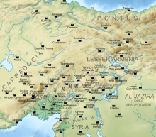
[1] Cappadocia, in this sense, was bounded in the south by the chain of mountains that separate it from Cilicia, to the east by the upper Euphrates, to the north by the Pontus, and to the west by Lycaonia and eastern Galatia.
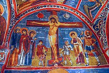
[2] The name, traditionally used in Christian sources throughout history, continues in use as an international tourism concept to define a region of exceptional natural wonders, in particular characterized by fairy chimneys,[3] in addition to its religious heritage of being a centre of early Christian learning, evidenced by hundreds of churches and monasteries (such as those of Göreme and Ihlara), as well as underground cities that were dug to offer protection during periods of persecution.
[7] Therefore, the recent modification of this proposal operates with the Hittite katta peda-, literally "place below" as a starting point for the development of the toponym Cappadocia.
[9] Herodotus wrote that the name of the Cappadocians was applied to them by the Persians, while they were termed by the Greeks "White Syrians" (Leucosyri),[10] who were most probably descendants of the Hittites.
The Cappadocians were named as one group (among "Parthians, Medes and Elamites; residents of Mesopotamia, Judea and Cappadocia, Pontus and Asia")[12] hearing the Gospel account from Galileans in their own language on the day of Pentecost shortly after the resurrection of Jesus Christ.
[13] Under the later kings of the Persian Empire, the Cappadocians were divided into two satrapies, or governments, with one comprising the central and inland portion, to which the name of Cappadocia continued to be applied by Greek geographers, while the other was called Pontus.
Due to its inland location and high altitude, Cappadocia has a markedly continental climate, with hot dry summers and cold snowy winters.
Cappadocia contained the sources of the Sarus and Pyramus rivers with their higher affluents, and also the middle course of the Halys, and the whole course of the tributary of the Euphrates later called Tokhma Su.
After the fall of the Hittite Empire, with the decline of the Syro-Cappadocians (Mushki) after their defeat by the Lydian king Croesus in the 6th century BC, Cappadocia was ruled by a sort of feudal aristocracy, dwelling in strong castles and keeping the peasants in a servile condition, which later made them apt to foreign slavery.
It was included in the third Persian satrapy in the division established by Darius but continued to be governed by rulers of its own, none apparently supreme over the whole country and all more or less tributaries of the Great King.
[21] Under Ariarathes IV, Cappadocia came into relations with Rome, first as a foe espousing the cause of Antiochus the Great, then as an ally against Perseus of Macedon.
Ariarathes V marched with the Roman proconsul Publius Licinius Crassus Dives Mucianus against Aristonicus, a claimant to the throne of Pergamon, and their forces were annihilated (130 BC).
The Ariobarzanes dynasty came to an end, a Cappadocian nobleman Archelaus was given the throne, by favour first of Antony and then of Octavian, and maintained tributary independence until AD 17, when the emperor Tiberius, whom he had angered, summoned him to Rome and reduced Cappadocia to a Roman province.
[26] For most of the Byzantine era it remained relatively undisturbed by the conflicts in the area with the Sasanian Empire, but the Persian Wars of the 610s and 620s placed Cappadocia on the frontline for the first time since the first century.
[29] The region suffered famine in 368 described as "the most severe ever remembered" by Gregory of Nazianzus: The city was in distress and there was no source of assistance [...] The hardest part of all such distress is the insensibility and insatiability of those who possess supplies [...] Such are the buyers and sellers of corn [...] by his word and advice [Basil's] open the stores of those who possessed them, and so, according to the Scripture, dealt food to the hungry and satisfied the poor with bread [...] He gathered together the victims of the famine [...] and obtaining contributions of all sorts of food which can relieve famine, set before them basins of soup and such meat as was found preserved among us, on which the poor live [...] Such was our young furnisher of corn, and second Joseph [...] [But unlike Joseph, Basil's] services were gratuitous and his succour of the famine gained no profit, having only one object, to win kindly feelings by kindly treatment, and to gain by his rations of corn the heavenly blessings.
[30] Basil also famously constructed near Caeserea the Basileias, a vast complex with hospices for sick, churches, quarters for travellers and facilities for doctors and nurses.
[31] The Arrival of Muslim Arab armies in the mid-seventh century resulted in the breakdown of civil and military order of the Eastern provices and a colossal displacement of population.
[27] The frontier zone between Caeserea (Kayseri) and Melitene became a no-man's land, in which the akritai and ghazis fought each other and which is remembered in the epic Digenes Akritas.
[32] The warfare, consisting of the yearly razzias as well as major campaigns took a heavy toll on the cities and villages, especially on the favourite Arab lines of march.
These traps are very creative, including such devices as large round stones to block doors and holes in the ceiling through which the defenders may drop spears.
Throughout the Dark Ages to the Middle Byzantine period, Armenians immigrated in significant numbers into Cappadocia, partly due to imperial policies.
With the decline and the fall of the Konya-based Seljuks in the second half of the 13th century, they were gradually replaced by successive Turkic ruled states: the Karaman-based Beylik of Karaman and then the Ottoman Empire.
Following the foundation of Turkey in 1922, those who still identified with this pre-Islamic culture of Cappadocia were required to leave, so this language is now only spoken by a handful of their descendants, most now located in modern Greece.
Sedimentary rocks formed in lakes and streams and ignimbrite deposits that erupted from ancient volcanoes approximately nine to three million years ago, during the late Miocene to Pliocene epochs, underlie the Cappadocia region.