Capricorn and Bunker Group
The Capricorn and Bunker group of islands of the southern Great Barrier Reef lies between 45 and 75 km (28 and 47 mi) from the adjacent departure ports and urban centres of Yeppoon, Gladstone, Town of 1770 and Bundaberg.
North West Island (105 hectares, 260 acres) is the largest coral cay in the Great Barrier Reef Marine Park.
The islands have high natural values, notably breeding populations of seabirds, marine turtles and coral cay vegetation.
Wednesday 23rd Continued our Course a long shore at the distance of about 2 Miles off having from 12 to 9, 8 and 7 fathom water until 5 oClock at which time we were abreast of the South point of a large open bay where in I intended to anchor.
][5] In 1803 Captain Eber Bunker of the whaling ship Albion was the first European to discover the region and gave his name to the southern group.
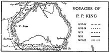
[6][7] The southern cays and reefs were first chartered between 1819 and 1821 by Lieutenant Phillip Parker King Royal Navy initially in Mermaid and later in Bathurst.
They were named Bunker Isles[8]The main charting exercise for all the islands and reefs was carried out in 1843 under the command of Captain Francis Price Blackwood in HMS Fly which was accompanied by Bramble.
In 1841 Blackwood was appointed to command the corvette HMS Flyin the first hydrographic survey commissioned by the Admiralty for exploring and charting the north-east Australian coast.
Fly, fitted with costly instruments, and carrying two scientists, Joseph Jukes, geologist, and John MacGillivray, zoologist, sailed from Falmouth in April 1842 with the cutter Bramble, under the charge of Lieutenant Charles Yule.
The crew of Fly landed on this island the following day The single tree (which was in fact a small clump of common pandanus of these seas, with its roots exposed above ground).......
Jan 21 Captain Blackwood and Mr Evans being ashore to "take sights" for the chronometers, found on the island some traces of the wrecked crew.
[9] The naturalist, Professor J. Beete Jukes, was on board HMS Fly and his published journal provides valuable information on some of the cays.
The steamer Lady Musgrave, which was chartered by the company for this work, returned to Bundaberg on Sunday afternoon, bringing Mr. A. E. Ellis, the local manager, and account forty Japanese, whose services are being dispensed with.
So bad was the weather, that in fourteen days the vessel was only able to Steam for fifty hours, the steamer having to take shelter behind one of the islands from the heavy squalls and rain.
Heavy weather was encountered, and at 3 p.m. on Sunday the line parted, and not withstanding all the efforts made, it proved impossible to pick up the ketch again, and it was decided to make for Burnett Heads, which were not reached, as stated, till 4 p.m. the same day.
[12][13] In 1932 Captain Christian Poulsen, engaged in bringing fishing parties to the reef, realised the potential of Heron Island as a tourist attraction.
The Capricorn and Bunker Cays form part of a distinct geomorphic province at the southern end of the Great Barrier Reef.
The sea level was much lower during the last ice age (at the end of the Pleistocene period) and the coastal plain on which today's reefs and cays developed was completely exposed.
[18] The Capricorn and Bunker Group contains 73–75 percent of all seabird biomass in the Great Barrier Reef World Heritage Area.
The islands making up the Capricorn and Bunker Groups provide habitat for thousands of nesting seabirds, including The breeding season is between October and April.
[22] Diana A wooden carvel schooner / brig of 103 tons and 70 feet in length built in Sydney in 1847 by the builder Ale and owned by C.L. Throck.
The vessel was a wooden carvel Brig of 145 tons and 85 feet in length and originally named David Henshaw built in Newcastle in Maine and had previously been registered at San Francisco (1849) at it arrived in Hobart on 17 April 1851 after having been purchased by Mr Boys for £700 stg.
Built in Nova Scotia by Jam in 1852 the vessel was struck by a squall during a voyage from Rockhampton to Richmond River under the command of McNeil.
A course was set to steer her ashore when the wind dropped, leaving her helpless to drift onto the reef where rising seas soon destroyed her no lives lost carrying ballast shallow site.
Departed from Sydney with general cargo for Broadsound; and ran aground on Lady Musgrave Is; maybe on Heron Is or One Tree Island or Masthead Reef.
The vessel was built in 1861 at Ulladulla New South Wales and registered in Sydney with the Official number of 36858 and a Registered number of 9/1861 with a gross tonnage of 80 tons and 82 feet in length[27] Hannah Broomfield a brigantine was lost on 30 April 1872 in the vicinity of the northern edge of the Capricorn Islands Most of her cargo and gear was recovered and the vessel was later refloated from Broomfield Reef but some time later wrecked in New Zealand in 1880.
The wreck is mostly flattened but her boilers a compound single screw motor, rudder and propeller still remain making it a nice change from the reef dives in the area.
Within 50metres of the Tambooroora lies the unidentified remains of a timber wreck and within half a mile lie two other wrecks of historical significance, including the wreck of the Polmaise, which the reef is named after, all four ships are declared historic shipwrecks[28] Deutschland A German wooden three-masted barque of 833 tons built in Ost Hammelwarden (Hamburg)., Germany in 1858 of 150 x 32 x 17.5 ft. hit Polmaise Reef on 22 July 1883 Carrying 1,000 tons of general cargo for Rockhampton from London including cast-iron screw piles for the Port Alma Wharf a church organ built to order in London for St. Pauls Church, this German barque ran onto Polmaise (Masthead?)
Eastminster An iron emigrant vessel of 226 feet and 1208 tons Built in Glasgow in 1876 Last seen after departing Maryborough after ignoring a warning from the pilot but still headed out to sea in a rising gale on 17 February 1888 bound for Newcastle, presumed lost during cyclone; wreckage reported on a coral reef approx.
While running from Brisbane to Cairns with passengers she ran gently on to North Reef near Heron Island, Queensland, 7 July 1926 and sent out an S.O.S call.