Carlton Hill, Brighton
First developed in the early and mid-19th century on steeply sloping farmland east of central Brighton, it grew rapidly as the town became a fashionable, high-class destination.
Carlton Hill's population was always poor, though, and by the early 20th century the area was Brighton's worst slum: overcrowding, crime and disease were rife.
This encouraged the development of terraced housing—the predominant housing pattern until the council undertook large-scale demolition and high-density rebuilding in the mid-20th century.
A cluster of historic early 19th-century houses and other structures survived the redevelopment, and several were awarded listed status by English Heritage.
[3] The high ground of the area reaches a summit of 230 feet (70 m) at Windmill Terrace, between Albion Hill and Richmond Street.
[3] The latter was Brighton's steepest road until redevelopment in the 1960s severed it: its 1:5 gradient necessitated a full-width wall halfway along, to intercept runaway handcarts and other vehicles.
[4] The area is not prominent on Brighton's skyline, but good views are possible from its streets, especially westwards and southwestwards towards the sea and across the valley floor in which Old Steine and the old town are situated.
[9] The laine had several furlongs; the second of these, which now forms the heart of the conservation area, was separated from its neighbours by leakways which became Carlton Hill (the road) and Sussex Street.
[12] Starting around 1800, the land was gradually sold to developers;[11] Edward Street was laid out in 1804 and quickly experienced a "mini building boom" with inns, stables and small workshops.
Number 1, also called St John's Lodge, was the largest, and was built for Edward Tarner (a merchant) and his wife Letitia, whose maiden name was Tilbury.
[5][17] It passed through the family until 1933, when Letitia Tilbury Tarner, a descendant, left it to her cousin Clara Isabella Bryan, who sold it in 1938 to Brighton Corporation for charitable purposes.
Brighton's fishing industry still thrived into the early 20th century, and many fishermen lived in Carlton Hill and used its workshops and warehouses to cure and smoke their herring catches.
[24] A contemporary writer, quoted by Brighton historian Clifford Musgrave, observed that "an aromatic and appetising pall would envelop the entire neighbourhood, kippering both fish and residents alike".
[3][26] Brighton's reputation was damaged by a disparaging article in The Lancet in 1882: making reference to Carlton Hill, it criticised the town's poor standards of health.
[22] Assisted by government funding, Brighton Corporation undertook extensive slum clearance from 1928 until the start of World War II, transforming the area's appearance.
[30] Two clinics, specialising in chest complaints and child welfare, opened on the north side of Sussex Street, opposite the market, in 1936 and 1938 respectively.
From 1959, the narrow, densely populated terraces between Albion Hill and Morley Street were cleared and replaced with landscaped open space and seven tower blocks—Brighton's first such buildings.
St John the Evangelist's Church, opposite the junction of Carlton Hill and White Street, was designed by George Cheesman junior in a "strangely bleak" Greek Revival/Neo-Georgian style in 1838, with Doric columns and a stuccoed and pedimented façade.
Wood built a new church in the Vernacular style on the opposite side of Richmond Parade, backing on to Ivory Place, in the same year.
[2][42] When the new Brighton National Spiritualist Church, a figure-of-eight concrete building, opened on Edward Street in 1965, the hall closed for good.
[57] It is on the boundary of the conservation area, between Sussex Street and Carlton Hill (the road) on the west side of Tilbury Place,[58] and is well screened by trees.
[59] Designed by British architecture firm Gollins Melvin and Ward,[66] the building had prominent white horizontal bands of glass-reinforced plastic and blue-tinted glazing, and its corners were chamfered to give it a more rounded appearance.
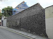
The high flint walls around it are described as a positive feature of the conservation area, although the building itself has a "neutral effect" according to the council's character statement.
Work by L.A. Mackintosh in 1957 altered the exterior; the architect added his personal monogram and an eagle emblem (representing John the Evangelist) above the left and right entrances respectively.
[78] Described as a "surprising survival",[79] the now semi-detached house is a two-storey cobble-fronted building with a prominent porch framed by Tuscan columns and topped by an entablature with a frieze and triglyph and a decorated pediment.
[78] The farmhouse's origins are unknown, although a Philip Mighell was a major landowner on Hilly Laine in the late 18th century, when some of the paul-pieces bore his name.
[82] On 4 July 2008, 4.05 acres (1.64 ha) at the heart of Carlton Hill was designated as the city of Brighton and Hove's 34th conservation area.
[58][84] All of Carlton Hill's listed buildings are within the designated area; these, combined with the sheltered open space of Tarner Park, substantial tree cover, the survival of old street patterns and boundary walls, and the distinctive lie of the land, contribute to the area's "special character", as defined by Brighton and Hove City Council.
Instead, a "disparate group of individually interesting buildings" and small spaces define the area;[75] together, they form "a fragment of early 19th-century Brighton".
[79] Flint and brown or yellow brick is used extensively, both for buildings within the conservation area and in associated structures such as boundary walls and pavements.