Province of Carolina
[citation needed] A Scottish contingent had meanwhile settled in South Carolina only to be extirpated by the Spanish, who inhabited Parris Island as late as 1655.
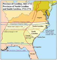
[7] On March 24, 1663, Charles II issued a new charter to a group of eight English noblemen, granting them the land of Carolina as a reward for their faithful support of his efforts to regain the throne of England.
[9] The King intended for the newly created province to serve as an English bulwark to contest lands claimed by Spanish Florida and prevent their northward expansion.
The actual government consisted of a governor, a powerful council, on which half of the councilors were appointed by the Lords Proprietors themselves, and a relatively weak, popularly elected assembly.
[12] In 1663, Captain William Hilton noted the presence of a wooden cross erected by the Spaniards that still stood before the town meeting house of the Indians living at what later became Port Royal.
[13] In 1665, Sir John Yeamans established a second short-lived English settlement on the Cape Fear River, near present-day Wilmington, North Carolina, which he named Clarendon.
Sayle arrived in Carolina aboard a Bermuda sloop with a number of Bermudian families to found the town of Charlestown.
Charles Town was made the principal seat of government for the entire province; Lord Shaftesbury specified its street plan.
Due to their remoteness from each other, the northern and southern sections of the colony operated more or less independently until 1691, when Philip Ludwell was appointed governor of the entire province.
[20] From 1708 to 1710, due to disquiet over attempts to establish the Anglican church in the province, the people were unable to agree on a slate of elected officials; consequently, there was no recognized and legal government for more than two years, a period which culminated in Cary's Rebellion when the Lords Proprietors finally commissioned a new governor.
He retained ownership of a sixty-mile-wide strip of land in North Carolina adjoining the Virginia boundary, which became known as the Granville District.