Carrickgollogan
Carrickgollogan (Irish: Carraig Uallacháin, meaning 'rock of Uallachán')[2] is a hill in Dún Laoghaire–Rathdown in Ireland, towards the southern border of the traditional County Dublin.
Some of the branches which form the Wood Brook or Crinken Stream rise on the south-western slopes, and, merging with others from near Shankill Castle and south of there, flow under the M11, past Allies River Road and on to the sea just north of Bray.
[7] To this end a flue 1+1⁄4 miles (2.01 kilometres) long running from the lead works and terminating at a chimney near the summit of Carrickgollogan was constructed in 1836.
[6][7] The distinctive granite flue chimney with its external spiral staircase and viewing platform quickly became a noted landmark and was marked on Admiralty charts as a point of reference for mariners.
[6] Photographic records show that the flue chimney was originally much taller with an extra brick section, now dismantled, rising above the viewing platform.
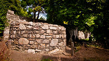
[9] As well as the remains of the flue chimney, a number of buildings from the smelting works situated in the valley below also survive to the present day.
These industrial buildings, all built from granite, include furnaces, purification tanks, lime kilns, stores, workers' cottages and manager's house.
[4] An earlier shot tower – described by Joyce as "a handsome and substantial structure, having a spiral stairs within, terminating in an artistic iron veranda on the outside"[12] – built in 1829 no longer survives.
[11] Further down the slopes to the north of the summit lies Rathmichael where the ruins of a church and round tower are found enclosed within the remains of what would once have been one of the largest ringforts in Ireland.
[13] Its dedication is believed to be to a saint called MacTail (later corrupted as "Michael") which would date the foundation of the monastery and church to the mid-seventh century.
[16] The ring wall and mound is approximately 350 feet (110 metres) in diameter and its size suggests the site was the base for an important chieftain.
[13] It is noted for its collection of grave slabs or leacs known as the Rathdown stones, nine examples of which can be found at the old church in Rathmichael attached to the south wall.
[21] No two stones are the same but share similar types of decoration in the form of concentric circles, cup marks and herring-bone patterns.
[27] Francis Erlington Ball in A History of the County Dublin suggests that the building was erected around 1537 by Peter Talbot to defend the lands from incursions by the O'Toole clan.
[29] James II visited the castle following the Battle of the Boyne in 1690 while his army was camped at nearby Lehaunstown and left a gift of silver for his host, Peter Lawless.
[32] On the east side of the mountain a wedge tomb with a 2.35 metres (7.7 feet) long gallery was discovered during the laying of a gas pipeline.