Carrizo Plain
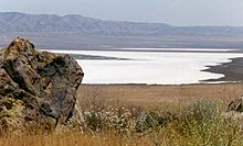
The San Andreas Fault occurs along the eastern edge of the Carrizo Plain at the western base of the Temblor Range.
At 5,106 feet (1,556 m), Caliente Mountain, southwest of the plain, stands as the highest point in San Luis Obispo County.
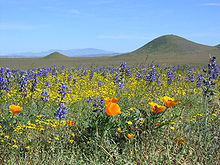
In addition to its spring wildflower displays,[7] Carrizo Plain is also famous for Painted Rock, a sandstone alcove adorned with pictographs created by the Chumash people around 2000 BC.
The creek has been carefully studied by geologists to find a correlation between the offset and historical events, such as earthquakes, that have occurred along the San Andreas Fault.
[10] Displacement on the San Andreas is responsible for the development of distinctive features, including shutter ridges, diverted or decapitated stream channels, and sag ponds.
[11] One feature relating to the San Andreas Fault and aligned to it in the Carrizo Plain is the Dragon's Back pressure ridge.
The Paso Robles formation is a Pleistocene aged alluvium deposit that reaches up to 3,000 ft (900 m) thick near the San Andreas fault and thins out towards the north and west.
The tule elk, pronghorn, black-tailed jackrabbit, western coyotes, and Le Conte's thrasher all also make their homes in the Carrizo Plain.
The hotter climate and ecology of Carrizo Plain allows the Le Conte's thrasher of the Southwestern United States to have a small disjunct range farther north than normal.
The goal of this plan was to: On January 12, 2001, President Bill Clinton signed a presidential proclamation establishing the Carrizo Plain as a national monument.
[17] "Manage the Carrizo Plain Natural Area (CPNA) so that indigenous species interact within a dynamic and fully functioning system in perpetuity while conserving unique natural and cultural resources and maintaining opportunities for compatible scientific research, cultural, social and recreational activities.
The administration partners of the CPNA work together to make decisions about the area and what needs to be taken care of in order to maintain the natural environment of the plain.
At BLM the staff consists of a project manager, a biological technician, a heavy equipment operator, a computer specialist, and a law enforcement ranger.
[19] When the CPNA Plan was implemented in the late 1990s, one of its first assignments was to gather information on the area's biological, cultural, recreational, and physical resources.
The information obtained by the management partners has helped to ensure that each decision made on behalf of the Carrizo Plain National Monument will benefit all of its resources.
Later in the season, the management team removes the cattle, giving native plants a competitive advantage versus the non-native vegetation.
Gypsum, a white mineral used in plasters and wallboards, is a plentiful resource in the plain found in shallow, low-grade areas.
The campground has eight picnic tables and firepits, and is frequently occupied by "day use" visitors, although overnight camping is also allowed.
One point of controversy was a buffer zone around the monument; opponents expected this would adversely affect nearby oil drilling sites.
[24] As it is separated from the major oil fields by the San Andreas Fault, and the underlying source rock, the Monterey Formation appears not to have been buried at the right conditions of temperature and pressure, and as the stratigraphy has not favored petroleum entrapment, accumulations of oil in economically recoverable quantities have not been found.
Vintage Production, a subsidiary of Occidental Petroleum, owned the mineral rights to 30,000 of the monument's 250,000 acres (101,000 ha).
The BLM approved the project in 2020 after their analysis showed that the new well posed no undue health or safety concerns, had no significant impacts to the environment and was consistent with management directives for the monument.
[27] The BLM issued an order to E&B Natural Resources to permanently close and remove 11 long-dormant oil wells, return the oil pads and more than 3 miles (4.8 km) of access roads to natural conditions, as well as removing pipelines, powerlines and other infrastructure from within the monument.
[28] The remote Carrizo Plain's status as one of the sunniest places in the state was exploited by the solar power industry from 1983 to 1994.
Instead of photovoltaic cells (as used by ARCO), however, Ausra will use Fresnel reflectors that concentrate solar energy onto pipes in a receiver elevated above the ground.
The concentrated solar energy boils water within a row of specially coated stainless steel pipes in an insulated cavity to produce saturated steam.
[29] Local opposition to some solar farm proposals centers on concerns about height above grade, noise and heat plume.
An investigative article by Los Angeles Times reporters Julie Cart and Maria LaGanga revealed that Braun discussed grazing extensively in correspondence just before her death.
Braun chose to allow Taylor Grazing Act allotments to expire and replaced them with free use permits.
Bakersfield District Office Manager Ron Huntsinger was brought in to oversee a continuation of the Taylor Grazing Act permit system.