Cartagena, Colombia
[6] The city's strategic location between the Magdalena and Sinú rivers also gave it easy access to the interior of New Granada and made it a main port for trade between Spain and its overseas empire, establishing its importance by the early 1540s.
The Puerto Hormiga Culture, founded in the Arjona Municipality of the Bolívar Department in the Caribbean coast region, particularly in the area from the Sinú River Delta to the Cartagena Bay, appears to be the first documented human community in what is now Colombia.
The primary reason for the proliferation of primitive societies in this area is thought to have been the relatively mild climate and the abundance of wildlife, which allowed the hunting inhabitants a comfortable life.
The rise of a much more developed culture, the Monsú, who lived at the end of the Dique Canal near today's Cartagena neighborhoods Pasacaballos and Ciénaga Honda at the northernmost part of Barú Island, has been hypothesized.
Mocana villages of the Carib people around the Bay of Cartagena included:[17] Heredia found these settlements "...largely surrounded with the heads of dead men placed on stakes.
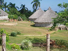
These tribes, though physically and administratively separated, shared a common architecture, such as hut structures consisting of circular rooms with tall roofs, which were surrounded by defensive wooden palisades.
[22][23][24][25] Under contract to Queen Joanna of Castile, Pedro de Heredia entered the Bay of Cartagena with three ships, a lighter, 150 men, and 22 horses, on 14 January 1533.
Proceeding onwards to Turbaco, where Juan de la Cosa had been mortally wounded 13 years earlier, Heredia fought an all-day battle before claiming victory.
[17]: 23 The city's increasing importance as a port for the export of Bolivian silver from Potosí to Spain, made it an obvious target for pirates and corsairs, encouraged by France, England, and Holland.
[29][full citation needed] In 1568, Sir John Hawkins tried to persuade Governor Martín de las Alas to open a trade fair in the city which would allow his men to sell foreign goods.
Francisco de Murga made the Inner Bay an "impregnable lagoon", according to Segovia, which included the forts El Boquerón, Castillo Grande, Manzanillo, and Manga.
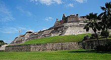
[17]: 31–32 When King Philip II employed the Italian engineer Juan Bautista Antonelli to design a master plan of fortifications for Cartagena, construction would actually continue for the next two hundred years.
This engineer continued the work to make Cartagena impregnable, including the construction from 1771 to 1778, of a 3400 yards long underwater jetty across the Bocagrande called the Escollera.
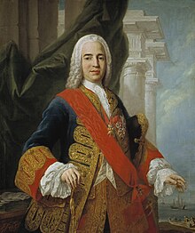
[28]: 55, 81–94 Among the censuses of the 18th century was the special census of 1778, imposed by the governor of the time, D. Juan de Torrezar Diaz Pimienta – later Viceroy of New Granada – by order of the Marquis of Ensenada, Minister of Finance – so that he would be provided numbers for his Catastro tax project, which imposed a universal property tax he believed would contribute to the economy while at the same time increasing royal revenues dramatically.
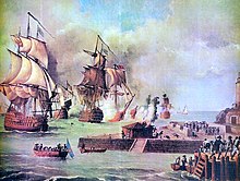
The city was defended by 3000 men, 360 cannons, and 8 ships plus ancillary small watercraft, under the command of Manuel del Castillo y Rada and Juan N. Enslava.
By 5 December, about 300 people per day died from hunger or disease, forcing 2000 to flee on vessels provided by the French mercenary Louis Aury.
[17]: 55–60 Finally, a patriot army led by General Mariano Montilla, supported by Admiral José Prudencio Padilla, laid siege to the city from August 1820 until October 1821.
The Liberator spent 18 days in the city from 20 to 28 July 1827, staying in the Government Palace in Proclamation Square and the guest of a banquet hosted by Jose Padilla at his residence on Calle Larga.
The Canal del Dique that connected it to the Magdalena River also filled with silt, leading to a drastic reduction in the amount of international trade.
During the presidency of Rafael Nuñez, who was a Cartagena native, the central government finally invested in a railroad and other infrastructure improvements and modernization that helped the city to recover.
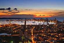
Zona Norte, the area located immediately north of the airport, contains hotels, the urban development office of Barcelona de Indias, and several educational institutions.
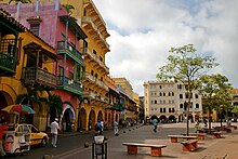
[citation needed] The old city walls, which enclose the centro or downtown area and the neighborhood of San Diego, are located to the southwest of Crespo.
The main entrance to downtown is the Puerta del Reloj (Clock Gate), which exits onto the Plaza de los Coches (Square of the Carriages).
Inside the Old City[clarification needed] is found Las Bóvedas (The Vaults),[56] a construction attached to the walls of the Santa Catalina Fortress.
Once a district characterized by crime, Getsemaní, just south of the ancient walled fortress, has become "Cartagena's hippest neighborhood and one of Latin America's newest hotspots", with plazas that were once the scene of drug dealing being reclaimed and old buildings being turned into boutique hotels.
It is located between Cartagena Bay to the east and the Caribbean Sea to the west, and includes the two neighborhoods of El Laguito (The Little Lake) and Castillogrande (Big Castle).
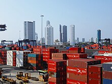
[60] According to the figures presented by DANE from the 2005 census, the ethnographic composition of the city is:[67] The main economic activities in Cartagena are industry, tourism, and commerce.
[89] International schools include: The city has many public and private libraries: The first carnivals and western theaters that served in New Granada operated on, what is today, Calle del Coliseo.
This was an activity patronized by the Viceroy Manuel de Guirior and Antonio Caballero y Góngora, who, like their predecessors, spent most of the time of their mandates ruling in Cartagena.
[93] The port, the fortresses and the group of monuments of Cartagena were selected in 1984 by the United Nations Educational, Scientific and Cultural Organization (UNESCO) as significant to the heritage of the world, having the most extensive fortifications in South America.