La Mota Castle (San Sebastian)
Apart from its location, the castle's primary defences were its thick walls (with access at three points, including to the keep, using drawbridges)[1] and, over time, its integration with the city's overall fortifications.
[8] That same year, the captain general of Guipúzcoa, Sancho de Leyva reported that Villaturiel only had a garrison of ten troops at San Sebastián, with old artillery pieces and arquebuses without ammunition.
[3] Following the death of Spannocchi, his successor, Jerónimo de Soto, also projected, in 1610, a citadel around La Mota but, again, no information has been found to date regarding its structure.
[3] During the Franco-Spanish War (1635–1659), major works were carried out by Marco Antonio Gandolfo, Pedro Texeira and Jerónimo de Soto, with the latter again insisting on the impregnable nature of La Mota.
That same year, Marco Antonio Gandolfo gave his favourable opinion and Garay presented a major project with all the previous proposals, including the citadel for the castle.
[3] In the second half of the 17th century, several works were projected by Alonso de Cepeda,[12] Francisco Domingo y Cueva, Octaviano Meni[3] and Hércules Torelli, the latter also reconstructing the castle keep following the explosion of the magazine in 1688, due to it being struck by lightning.
[6] In 1693, work was concluded on one of the most important projects, the Mirador battery, on the east slope of Mount Urgull, to cover the approach from the sea and from La Zurriola beach.
[3] Having invested San Sebastian on 30 June, the French, under the Duke of Berwick, began positioning batteries along the Urumea where the city's walls were most vulnerable.
As was the convention at the time, and following instructions given by Philip V's favourite, Alberoni,[6] the Spanish commander Alejandro de la Motte requested a parley and his garrison were allowed to retreat into the castle, leaving the remainder of the city to French control.
Meanwhile, Berwick was able to establish batteries with a clearer range on the castle, and launched fresh bombardments of mortar fire which struck the magazine, and also destroyed the garrison's food provisions.
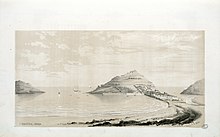
Thus, the city's location on a narrow peninsula provided some natural protection, with the estuary of the River Urumea to the east and to the west, "a tiny bay about sixteen hundred yards across at its broadest," further limiting access.
Its man-made fortifications included a high wall, eight feet thick, with the bastion of St. Elmo at the north-eastern angle, and the two small towers of Los Hornos and Las Miguetas towards the southern end with a bastion in the centre, "covered by a hornwork, with the usual counterscarp, covered way and glacis; but these works were dominated throughout by the neighbouring heights [the hills of Igueldo and Orgullo] which were in range of cannon".
On 5 March 1808, faced with an assault on the city by Marshal Bessières' Corps of Observation of the Pyrenees, the governor of San Sebastian, under orders from Madrid not to resist, surrendered.
[15] The following July, Napoleon and his brother, the new King of Spain, José Bonaparte, entered San Sebastián, which would remain under French control until the British siege in 1813.
San Sebastian was blockaded, rather than besieged, by French troops under Jean Bourke from the first week of April until September, when General Étienne Ricard finally entered the city, taking the castle on 3 October.
[6] The Legion, raised ad hoc for intervention in Spain, was a force whose junior or senior officers at the time included, apart from its commanding officer, Lacy —whose active service included being with Wellington at Waterloo—, such notable military figures as William Reid, Charles Shaw, John Le Marchant, John Owen, Duncan MacDougal, xxxx,[20] and Maurice O'Connell,[21] consisted, initially, of ten infantry regiments (two of which would be dissolved in the winter of 1836, due to the typhoid epidemic), a rifle regiment and two lancer regiments (700 horse) which, together with Engineers, Artillery, and the medical corps, etc., numbered some ten thousand men.