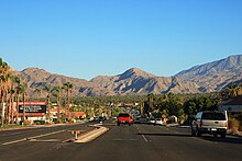
Cathedral City, California
Today every other square mile of the city is part of the Agua Caliente Band of Cahuilla Indians reservation land.
[12] On November 7 of that year he established the initial point, in the San Bernardino Mountains, from which all subsequent surveys in Southern California would be based.
[12] Besides Colonel Henry Washington, there were occasional explorers, colonizers and soldiers that made their way through the area during the Spanish, Mexican, and early American eras, but none established any permanent structures or residences.
Prior to the 1860s the only regularly traveled routes through the Coachella Valley were trading paths used by the Cahuilla and other Native American tribes.
One of these paths, on the southwestern side of the valley, followed the base of the San Jacinto and Santa Rosa mountains somewhere near the Whitewater River, and would have passed through the area that would become Cathedral City.
Early non-native explorers, surveyors, and military, such as Colonel Washington, made use of these routes, but regular transportation services were not established until 1862.
Later that year he hired a guide, and with the help of the Cahuilla and Maricopa Indians, mapped a route from San Bernardino, California, through the San Gorgonio Pass and Coachella Valley, past the northern shore of the Salton Sink, through the passes between the Chuckwalla and Chocolate Mountains, and up to the Colorado River across from La Paz in the New Mexico Territory, (now the state of Arizona).
Shortly after Bradshaw defined the trail from San Bernardino to La Paz, various stagecoach and freight companies began using the route.
The stage and freight lines brought miners, supplies, and mail between San Bernardino and La Paz, and the route became known as the Bradshaw Trail or "Gold Road".
The stage and freight lines were eventually supplanted by the railroads, but the trail would later become the basis for Palm Canyon Drive and Highway 111 that run through the city today.
In 1931, Al and Lou Wertheimer of the reputed Detroit "Purple Gang" opened the Dunes Club just outside Palm Springs' city limits.
In 2002, a grassroots group suggested that Cathedral City merge with Palm Springs[17] but the concept did not move forward.
A new city hall was built, as well as the IMAX/Mary Pickford movie theater complex, along with a total of 130 acres (0.53 km2) of new or remodeled stores and restaurant space.
Cathedral City hosts an annual Mexican Independence Day festival on every third weekend of September.
The country club is built on land leased from the Agua Caliente Indian Reservation, and includes a retirement community of manufactured homes that line the greens.
[26] In 2018–19, the So Cal Coyotes changed leagues and now play in Indio, California in the Shadow Hills High School football stadium.
Cathedral City is in Supervisorial District 4 of Riverside County, represented by Democrat V. Manuel Perez.
[30] The tribal council of the Agua Caliente Band of Cahuilla Indians governs over parts of the city where reservation jurisdictions overlap.
The varsity football, basketball and soccer teams had earned CIF-southern California championship runs in the late 1990s and 2000s.
The city was a winter residence for actors Robert Duvall and Martin Landau in the 1960s,[citation needed] and TV show host Monty Hall in the 1990s.
[citation needed] Frank Sinatra's grave is located in Desert Memorial Park cemetery, as are those of several other prominent figures, including actor William Powell, singer-songwriter Sonny Bono, former mayor of Palm Springs, and actress Jane Wyman.