Caversham, New Zealand
It is sited at the western edge of the city's central plain at the mouth of the steep Caversham Valley, which rises to the saddle of Lookout Point.
Major road and rail routes south lie nearby; the South Island Main Trunk railway runs through the suburb, and a bypass skirts its main retail area, connecting Dunedin's one-way street system with the Dunedin Southern Motorway.
The suburb was founded by wealthy pioneer William Henry Valpy, and its name reflects his family connections with the town of Reading, in the English county of Berkshire.
Other notable people with Caversham connections include politician Thomas Kay Sidey, architect Edmund Anscombe, and surveyor John Turnbull Thomson.
[3] The suburbs of Balaclava and Maryhill lie to the north, close to the western end of the ridge that runs along the northern edge of central Dunedin.
[7] To the northeast of the Glen, a hill spur including a 20-metre (66 ft) cliff separates Caversham from the central part of the city.
It is occasionally referred to as "Hillside", after the house of the city's founding father Captain William Cargill which was located here.
[12] Lookout Point is also the home of the former Caversham Industrial School, located to the northeast of the fire station on Mornington Road.
[12] A major flyover was constructed at Lookout Point in the early 2000s, allowing routes to the suburbs of Corstorphine and Maryhill to connect without having to negotiate a junction with the start of the Dunedin Southern Motorway.
[14][15] Caversham was named for Caversham, Berkshire, a suburb of Reading, by William Henry Valpy, a wealthy early settler who farmed the areas around the lower slopes of Forbury Hill; his initial farm, "The Forbury", was located in what is now St Clair, close to a street which now bears his name.
[16] In the early days of Dunedin, it was impossible for a dray to reach the Caversham Valley in wet weather unless it went by a circuitous route around the hills.
Valpy solved this problem by hiring men at his own expense to build a crude road from the southern end of Princes Street to his farm at Forbury.
[17] The road curved around the edge of the hills at the Glen to avoid a large swamp, the site of which was occupied by Carisbrook sports ground until 2011.
[5] By the end of the decade, Caversham had its own school, post office, drill hall (from the Southern District Rifles), and Anglican and Presbyterian churches.
[19] Several charitable organisations have had properties in Caversham, including the Otago Benevolent Institution home for invalids, and an IHC New Zealand centre at Kew Park.
This database is unique in its size for a historical study within New Zealand or Australia,[29] and has allowed for the examination and publication of details relating to the socioeconomic and demographic mix of early Dunedin.
By using both quantitative and qualitative analyses, and by including considerable amounts of oral history, it has allowed for a vivid recreation of the society of early urban New Zealand.
[47] The school was named for the late wife of Mark Cohen, city councillor, campaigner for women's rights, and editor of the Evening Star newspaper from 1893 to 1920.
Local industries at the beginning of the twentieth century included a brickworks, a gasworks, breweries, a smithy, milliners, several bakeries, a tannery, a bootmakers, and Rutherford's Wax Vesta match factory at Forbury Corner.
Hillside Road becomes increasingly light industrial as it approaches South Dunedin, with automotive engineers, car sales yards, joineries, a rope factory, and a funeral parlour.
Carisbrook, the city's former main rugby union venue and a former Test cricket ground, was located at the eastern end of the suburb between The Glen and the Hillside Railway Workshops prior to its demolition.
[55] Other than Carisbrook, the suburb's main sports ground is Bathgate Park, which lies at the border of Caversham and South Dunedin in the southeast.
Despite its name, Caversham play at Tonga Park, located in the adjacent suburb of Forbury, a ground they share with the Carisbrook-Dunedin Cricket Club.
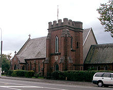
The Presbyterian church is located on Thorn Street, roughly halfway between the South Road retail area and Forbury Corner.
[75] Unusual among Dunedin buildings, this church has a formal Classical style, with its brickwork augmented by pediments and square columns.
[79] Part of the factory of Donaghy's Industries, adjacent to the eastern edge of Bathgate Park, is notable because of its unusual shape.
During his time as provincial Chief Surveyor, Thomson explored and mapped large sections of the interior of the southern South Island.
The latter of these lies at the Glen at the eastern end of Caversham, providing a link between South Road and the hill suburbs of Maryhill, Balaclava, and Mornington.
[21] It now carries State Highway 1 away from the retail heart of the suburb, connecting at its northern end with the city's one-way street system.
[93] A junction at the north end of Caversham's main retail area connects South Road with the bypass.