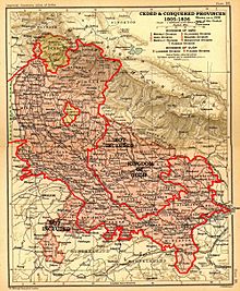
Ceded and Conquered Provinces
[1] At the start of the 19th century, only the Benares division and the fort of Allahabad in present-day Uttar Pradesh were under British rule.
[1] The territory included the Gorakhpur and Rohilkhand divisions; the districts of Allahabad, Fatehpur, Cawnpore, Etawah, Mainpuri, Etah; the southern part of Mirzapur; and the terai parganas of Kumaun, and came to be known as the Ceded Provinces.
[1] In 1816, under the Treaty of Sugauli signed at the conclusion of the Anglo-Nepalese War (1814–1816), the Kumaon division and Dehradun district of present-day Uttarakhand state were annexed as well.
[2] In response, a number of temporary arrangements were attempted, but proved to be less than optimal; finally, in 1831, an independent Board of Revenue and a separate Sadr Diwani and Nizamat Adalat (Chief Civil and Criminal Courts) were created for these provinces.
4. c. 52) renamed the region the North Western Provinces, this time to be administered by a Lieutenant-Governor, the first of whom, Sir Charles Metcalfe, would be appointed in 1836.