Central Croatia
Croatia proper comprises several smaller regions of its own: Lika, Gorski Kotar, Zagorje, Međimurje, the Croatian Littoral, Podravina, Posavina, Kordun, Banovina, Prigorje, Turopolje, Moslavina, and Žumberak.
The Dinaric Alps area is typified by karst topography, while the Pannonian Basin exhibits plains, especially in the river valleys—along the Sava, Drava, and Kupa—interspersed with hills and mountains developed as horst and graben structures.
The region belongs almost exclusively to the Black Sea drainage basin and includes most of the large rivers flowing in Croatia.
The west of the region represents a natural barrier between the Adriatic Sea and the Pannonian Basin, and this, along with Ottoman conquest and resulting military frontier status, has contributed to the relatively poor development of the economy and infrastructure of that area.
[9] Croatia proper comprises several smaller historical regions of its own: the Croatian Littoral, Lika, Gorski Kotar, Zagorje, Međimurje, Podravina, Posavina, Kordun, Banovina, Prigorje, Turopolje, Moslavina, and Žumberak.
The sociogeographical distinction between Central Croatia, the Croatian Littoral and Mountainous Croatia has become more pronounced over time, as the western, mountainous areas of Lika and Gorski Kotar suffered from population depletion during the 20th century, especially during World War II and the Croatian War of Independence.
[14] The Pannonian Basin took shape through Miocenian thinning and subsidence of crust structures formed during the Late Paleozoic Variscan orogeny.
[15] Ultimately up to 3,000 metres (9,800 ft) of sediment was deposited in the basin, and the sea eventually drained through the Iron Gate gorge.
[21] A high degree of karstification of the terrain in the Dinaric Alps has resulted in an increased permeability of soil and rocks and the formation of travertine barriers and waterfalls.
Furthermore, there are losing streams such as Gacka, Krbava and Lika rivers, reflecting a high degree of karstification of the terrain in the region, resulting in increased permeability of soil and rocks.
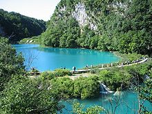
[27] Probably the finest example of interaction of karst terrain and watercourses in the area are Plitvice Lakes—16 interlinked lakes between Mala Kapela and Plješevica, through which Korana River flows.
The area is abundant in travertine barriers, waterfalls and caves of biological origin—created through deposition of calcium carbonate through agency of moss, algae and aquatic bacteria.
Temperature peaks are pronounced in the region compared to parts of Croatia closer to the Adriatic Sea, because of the absence of its moderating effect.
Gorski Kotar mountain peaks of Risnjak and Snježnik receive the greatest precipitation in Croatia—3,500 millimetres (140 inches) per year.
Zagreb is the largest city in Croatia proper, followed by Rijeka, Karlovac, Varaždin, Sisak, and Velika Gorica.
Its most significant components are wholesale and retail trade, accounting for 38.1% of the city's economic income, followed by the processing industry, encompassing 20.3% of the economy of Zagreb.
Unlike the economy of the city of Zagreb, the county's economic income is largely generated by small and medium businesses (64.6%).
[41][42] Pipeline transport infrastructure in the region comprises the Jadranski naftovod (JANAF) pipeline, connecting the Sisak and Virje crude oil storage facilities and terminals to a terminal in Slavonski Brod further east on the Sava River, and the Omišalj oil terminal—a part of the Port of Rijeka.
[43] The region forms a center of Croatia's natural gas supply system, based on an underground storage facility located approximately 50 kilometres (31 miles) east of Zagreb.
[44] The Dinaric mountain ranges of Lika and Gorski Kotar in the region's western reaches represent a natural barrier between the Adriatic Sea to its west and the Pannonian Basin and to its east, traversed by few high-performance transport routes until recently.
The region was first spanned by a trading route between Senj and Pannonia in classical antiquity and later in Middle Ages, but the first modern road in the area was the Caroline road, completed in 1732 connecting Rijeka and Karlovac via Fužine, Mrkopalj, Ravna Gora and Vrbovsko, and named after Charles VI who ordered its construction.
This also allowed preservation of numerous cultural heritage sites, including medieval city cores, hill forts, manor houses, castles, palaces, and churches.
[49] The region contains most of the 180 preserved or restored castles and manor houses in Croatia—most of the best preserved-ones were built in the 17th and 18th centuries, when the Ottoman conquest was no longer a threat.
[52] The landmarks include the Zagreb Cathedral, founded in 1093 and rebuilt numerous times since, the last major reconstruction being after the 1880 earthquake.
Modern history recorded the first Ottoman raids in the area in the late 15th century after fall of the Medieval Kingdom of Bosnia—culminating in the Battle of Krbava Field in 1493.
The extent of the Ottoman conquest still marks the southern and eastern boundaries of Croatia proper as a geographical region.
[61][62] Following World War I and the Treaty of Trianon, Hungary lost Rijeka and Međimurje, as well as other territories, to the newly established Kingdom of Serbs, Croats and Slovenes.
[63][64] The 1921 constitution defined the country as a unitary state and abolished the historical administrative divisions, effectively ending Croatia's autonomy.
[65] Međimurje was assigned to Croatia in 1947—when all the borders of the former Yugoslav constituent republics were defined by demarcation commissions, pursuant to decisions of the AVNOJ of 1943 and 1945.
The Croatian Army campaign ended following the surrender of the last operational corps of the RSK military in Viduševac, near Glina.