Central Freeway
[6] The 1948 Transportation Plan for San Francisco, prepared by De Leuw, Cather and Company, included the Central Freeway.
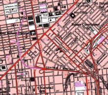
After swinging northeast and back north to the east side of Van Ness Avenue (continuing as a double-decked structure between Van Ness Ave. and Polk Street), a pair of ramps would split to the east, taking downtown traffic to and from the one-way pair of Bush and Pine Streets.
At Clay Street, the freeway would descend to meet the rising terrain, ending at Broadway just east of Van Ness Avenue as a single level depressed roadway.
[7] The route was also included in the 1955 city master plan, by then extending north beyond the former Broadway terminus to the proposed Golden Gate Freeway near Lombard Street.
[citation needed] There was a plan promulgated in February 1962 to relieve traffic congestion on the Golden Gate Bridge by constructing a "San Francisco-Tiburon Bridge" from Van Ness Ave. at Aquatic Park in San Francisco north across the Golden Gate Strait to Tiburon to connect with the Redwood Highway, which would have been anchored on Angel Island.
[14] In 1989, the Loma Prieta earthquake damaged the northern part of the elevated roadway, and in 1992 Caltrans removed the freeway north of Fell Street and rerouted U.S. 101 to exit at Mission Street and onto the portion of Van Ness Avenue between the Central Freeway and Turk Street/Golden Gate Avenue.
That year the Board of Supervisors banned any new freeway construction north of Market Street; a city task force recommended its replacement with a surface boulevard in 1995.
[23] Except where prefixed with a letter, postmiles were measured on the road as it was in 1964, based on the alignment that existed at the time, and do not necessarily reflect current mileage.