New Jersey Route 158
At the western end in Newark it ran just south of Park Place, beginning at Center Street.
Eventually, the upper level roadway was designated by the New Jersey State Highway Department as Route 25AD.
The highway continued eastward, crossing the last patch of land between 21 and the river before heading onto the swing bridge.
The route continued onto land just north of New Jersey Railroad Avenue, where it turned northward along First Street.
[3] A cutoff around the bridge opened in 1870 and the old route became the Centre Street Branch of the New Jersey Railroad, being cut from the main line to the south when the latter was elevated around 1904.
The proposal asked for $45,000 (1901 USD) in improvements of dredging and maintaining the channel of the Passaic River below the bridge.
[7] On April 2, 1911, almost ten years after the proposed improvements, construction began on a new high-speed line in Newark along the Hudson and Manhattan Railroad.
The last rail that had to be constructed was completed that very day for the eighty-six Newark-bound trains to run in each direction of that line.
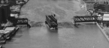
On June 27, 1937, a proposal was made by the city of Newark and the counties of Hudson and Essex to convert the upper level of the span to a roadway after proposing that the Hudson and Manhattan Railroad, now the Port Authority Trans-Hudson, to be moved onto tracks that paralleled Route 21, which was assigned in 1927.
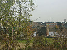
Route 158's official decommissioning date is currently unknown, but the Centre Street Bridge was torn down around 1979.