Centre of Canada
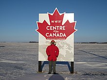
The rural village of Taché, Mantioba, east of Winnipeg on the Trans-Canada Highway, has a sign at 96°48'35"W that proclaims it the longitudinal centre of Canada.
The most readily understood would be by taking the mid-point of the extremities of the Canadian landmass section, above.
The resulting location 62°24′N 096°28′W / 62.400°N 96.467°W / 62.400; -96.467 (62 degrees 24 minutes North, 96 degrees 28 minutes West) is located just south of Yathkyed Lake in Nunavut, west of Hudson Bay.The nearest inhabited places to this point are Baker Lake, Nunavut well to the north, and Arviat to the east.
A sign that proclaims the point as the geographic centre of Canada was added in 1959.
[1] The pole of inaccessibility of Canada (the point furthest from any coastline or land border) is near Jackfish River, Alberta at 34-115-17-W4 (Latitude: 59°1′ 48" N, Longitude: 112°49′ 12" W).