Chaco Culture National Historical Park
Containing the most sweeping collection of ancient ruins north of Mexico, the park preserves one of the most important pre-Columbian cultural and historical areas in the United States.
[a] Chacoans quarried sandstone blocks and hauled timber from great distances, assembling fifteen major complexes that remained the largest buildings ever built in North America until the 19th century.
Many Chacoan buildings may have been aligned to capture the solar and lunar cycles,[5] requiring generations of astronomical observations and centuries of skillfully coordinated construction.
The sites are considered sacred ancestral homelands by the Hopi and Pueblo people, who maintain oral accounts of their historical migration from Chaco and their spiritual relationship to the land.
The canyon itself, located within lowlands circumscribed by dune fields, ridges, and mountains, is aligned along a roughly northwest-to-southeast axis and is rimmed by flat massifs known as mesas.
The alluvial canyon floor slopes downward to the northwest at a gentle grade of 30 feet per mile (6 m/km); it is bisected by the Chaco Wash, an arroyo that rarely has water.
[citation needed] After the Pangaean supercontinent sundered during the Cretaceous period, the region became part of a shifting transition zone between a shallow inland sea—the Western Interior Seaway—and a band of plains and low hills to the west.
A sandy and swampy coastline oscillated east and west, alternately submerging and uncovering the area atop the present Colorado Plateau that Chaco Canyon now occupies.
[14] The Chaco Wash flowed across the upper strata of what is now the 400-foot (120 m) Chacra Mesa, cutting into it and gouging out a broad canyon over the course of millions of years.
Chaco Canyon lies on the leeward side of extensive mountain ranges to the south and west, resulting in a rainshadow effect that fosters the prevailing lack of moisture in the region.
[18] Chacoan flora typifies that of North American high deserts: sagebrush and several species of cactus are interspersed with dry scrub forests of piñon and juniper, the latter primarily on the mesa tops.
[21] Among Chacoan mammals are the plentiful coyote (Canis latrans); mule deer, elk, and pronghorn also live within the canyon, although they are rarely encountered by visitors.
The broad arc of their cultural elaboration culminated around 800, during the Pueblo I Era, when they were building crescent-shaped stone complexes, each comprising four to five residential suites abutting subterranean kivas,[24] large enclosed areas reserved for rites.
Hewett and others helped enact the Federal Antiquities Act of 1906, the first U.S. law to protect relics; it was, in effect, a direct consequence of Wetherill's controversial activities at Chaco (including amateur excavations, reuse of ruin materials for building, and a large livestock ranching operation).
[51] The park has a visitor center featuring the "Chaco Collection Museum", which has not been open to the public since being completed in 2017,[52][53] an information desk, a theater, a book store, an observatory,[54][55] and a gift shop.
[58] Chacoan relics outside the current park's boundaries have been threatened by development: an example was the proposed competitive leasing of federal lands in the San Juan Basin for surface coal mining beginning in 1983.
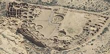
[citation needed] Casa Rinconada, isolated from the other central sites, sits to the south side of Chaco Wash, adjacent to a Chacoan road leading to a set of steep stairs that reached the top of Chacra Mesa.
Its location made the community visible to most of the inhabitants of the San Juan Basin; indeed, it was only 2.3 miles (3.7 km) north of Tsin Kletzin, on the opposite side of the canyon.
Research at the site conducted by archaeologist Tom Windes suggests only a handful of families, perhaps as few as five to twenty, lived in the complex; this may imply that Pueblo Alto served a primarily non-residential role.
[67] Tsin Kletzin ("Charcoal Place"), a compound located on the Chacra Mesa and positioned above Casa Rinconada, is 2.3 miles (3.7 km) due south of Pueblo Alto, on the opposite side of the canyon.
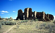
Comprising at least two stories and 124 rooms,[66] it shares an arc or D-shaped design with its contemporaries, Peñasco Blanco and Pueblo Bonito, but has a unique "dog leg" addition made necessary by topography.
[82][83] Their depressed and scraped caliche beds reach 30 ft (9.1 m) wide; earthen berms or rocks, at times composing low walls, delimit their edges.
[4] Two whorl-shaped etchings near the top of Fajada Butte compose what is called the "Sun Dagger" petroglyph that is tucked behind the eponymous rock panels of the "Three-Slab Site".
The latter left-hand spiral captured both spring and fall equinoxes; its artifice was revealed by a descending spear of light, filtered through the slabs, that shone upon it and split it in two.
[88] Public access to the butte was curtailed when, in 1989, erosion from modern foot traffic was found to be responsible for one of the three screening slabs at the "Sun Dagger" site shifting out of its ancient position; the assemblage of stones has thus lost some of its former spatial and temporal precision as a solar and lunar calendar.
[89] Some parties have advanced the theory that at least 12 of the 14 principal Chacoan complexes were sited and aligned in coordination, and that each was oriented along axes that mirrored the passing of the Sun and Moon at visually pivotal times.
[86] The great houses of Pueblo Bonito and Chetro Ketl were found by the "Solstice Project" and the U.S. National Geodetic Survey to be sited along a precisely east–west line, an axis that captures the passage of the equinox sun.
[9] Two shared-latitude but diametrically opposed complexes, Pueblo Pintado and Kin Bineola, are located some 15 mi (24 km) from the core buildings of the central canyon.
[6] Two other complexes that are less distant from Pueblo Bonito, Una Vida and Peñasco Blanco, share an axis collinear with the passage of the full "maximum moon".
The terms "minimum" and "maximum" refer to the azimuthal extreme points in the lunar excursion cycle, or the swings in direction relative to true north that the setting full moon exhibits.


![Large square map of northwestern New Mexico and neighboring parts of, clockwise from left, western Arizona, southeastern Utah, and southwestern Colorado. The map region has a green and blocky rectangular-crescent area at its center labeled "Chaco Culture National Historical Park". Radiating from the green region are seven segmented gold lines: "[p]rehistoric roads", each several dozen kilometers in length when measured according to the map scale factor. Roughly seventy red dots mark the location of "Great House[s]"; they are widely spread across the map, many of them far from the green area, near the extremes of the map, more than one hundred kilometers from the green area. Two proceed roughly south, one southwest, one northwest, one straight north, and the last to the southeast. Yellow dots mark the location of modern settlements: "Shiprock", "Cortez", "Farmington", and "Aztec" to the northwest and north; "Nageezi", "Cuba", and "Pueblo Pintado" to the northeast and east; "Grants", "Crownpoint", and "Gallup" to the south and southwest. They are connected by a network of gray lines marking various interstate and state highways. A fan of thin blue lines along the northern margins of the map depict the San Juan River and its communicants.](http://upload.wikimedia.org/wikipedia/commons/thumb/6/6a/Prehistoric-Roads.jpg/350px-Prehistoric-Roads.jpg)