Chad Basin
The basin spans four modern nations, including most of Chad and a large part of Niger, Nigeria and Cameroon.
In the northeastern part of the Benue Trough where it enters the Chad Basin there are marine sediments from the Late Cretaceous (100.5–66 Ma[a]).
[4] For most of the Quaternary, from 2.6 million years ago to the present, the basin seems to have been a huge, well-watered plain, with many rivers and water bodies, probably rich in plant and animal life.
[4] During the Holocene, from 11,000 years ago until recently, a giant "Lake Mega-Chad" covered an area of more than 350,000 square kilometres (140,000 sq mi) in the basin.
Stratigraphic records show that "Mega-Chad" varied in size as the climate changed, with a maximum about 2,300 years ago.
Elephants almost became extinct by the end of the nineteenth century due to European and American demand for ivory, but stocks have since recovered.
They converge to form the Yobe, which defines the border between Niger and Nigeria for 300 kilometres (190 mi), flowing into Lake Chad.
[9] The Central African Republic (CAR) contains the sources of the rivers Chari and Logone, which flow north into the lake.
[9] The basin in the Nigerian section contains an upper aquifer of Early Pleistocene alluvial deposits that are often covered by recent sand dunes, varying in thickness from 15 to 100 metres (49 to 328 ft).
There has been a proposal to supply water from the Congo Basin via a canal 2,400 kilometres (1,500 mi) long, but major political, technical, and economic challenges would have to be overcome to make this practical.
[9] Humans have lived in the inner Chad Basin from at least eight thousand years ago, and were engaging in agriculture and livestock management around the lake by 1000 BC.
[9] By the 5th century AD camels were being used for trans-Saharan trade via the Fezzan, or to the east via Darfur, where slaves and ivory were exchanged for salt, horses, glass beads, and, later, firearms.
[16] After the Arabs conquered North Africa during the 7th and 8th centuries, the Chad Basin became increasingly linked to the Muslim countries.
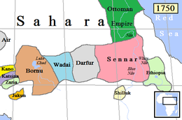
[17] The Kanuri people commanded by the Sayfuwa migrated to the west and south of the lake, where they established the Bornu Empire.
[18] Satellite states of Bornu included the Sultanate of Damagaram in the west and Baguirmi to the southeast of Lake Chad.
[21] During the Berlin Conference in 1884-85 Africa was divided between the European colonial powers, defining boundaries that are largely intact with the present post-colonial states.
A boundary was agreed along a line from Say on the river Niger to Barruwa on Lake Chad, but leaving the Sokoto Caliphate in the British sphere.
[25] During the next twenty years a large part of the Chad Basin was incorporated by treaty or by force into French West Africa.
The area is badly affected by the Boko Haram insurgency, which began in 2009 and is centred on Borno State in northeastern Nigeria.
[9] Ethnic groups include Kanuri, Maba, Buduma, Hausa, Kanembu, Kotoko, Bagger, Haddad, Kuri, Fulani and Manga.
The largest cities are Kano and Maiduguri in Nigeria, Maroua in Cameroon, N'Djamena in Chad and Diffa in Niger.
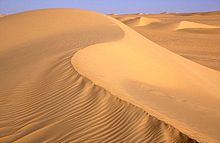
[10] Nomadic herders migrate with their animals into the grasslands of the northern part of the basin for a few weeks during each brief rainy season, where they intensively graze the nutritious grasses.
[29] During the period 2000-01, fisheries in the Lake Chad basin provided food and income to more than 10 million people, with a harvest of about 70,000 tons.
[28] Fisheries have been managed traditionally by a system where each village has recognized rights over a defined part of the river, wetland or lake, and fishers from elsewhere must seek permission and pay a fee to use this area.
[31] Local governments and traditional authorities are increasingly engaged in rent-seeking, collecting license fees with the help of the police or army.