Chain of Craters Road
As of 2018, the road has had parts covered by lava in 41 of the past 53 years, due to eruptions of Kīlauea volcano.
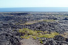
[1] The road begins at the highest part of the eastern rift zone where frequent rains created a rainforest.
[2][8] Between September and November 2014, work was carried out to reopen Chain of Craters Road, initially as a one-lane graveled surface, to serve as an emergency road for the residents of Lower Puna, who were in danger of being cut off if the June 27 flow had crossed Highway 130 at Pāhoa.
The 2018 lower Puna eruption prompted a similar repair, but the road remains closed to non-emergency use by automobiles.
Because of the dangers posed by an active volcano, the US Geological Survey posts a daily conditions report.
In April 2008, the area was rated as dangerous with a high alert, because of volcanic activity and sulfuric gas.