Chapeltoun
The Topographical Dictionary of Scotland in 1846 states that "About a mile from the town (Stewarton), on the farm of Chapelton (now Chapeltoun Mains), were recently dug up the foundations of an ancient chapel, of which however, no authentic records have been preserved."
In 1842[13] it is recorded that "Near the farm house of Low Chapelton, above a mile below Stewarton, on the right bank of the Annock, there appears to have once been a chapel, the ruins of which were lately dug up, when the proprietor was engaged in planting trees.
"[14] The Ardossan & Saltcoats Herald on 28.11.1863 ran an article that stated that: "The Chaplehill, an artificial mound, not unlike the one at Castleton, as large, (some people think larger) and of an equally perfect shape.
"[15] The Scotsman for Wednesday, 26 September 1866 records the sale of the 176 acre estate and states that the dwelling house was built around the ancient chapel of St Mary, being repaired and improved.
A Moot Hill of Chapelton is recorded in the Register of the Great Seal of Scotland as being specifically excluded by King James from a grant of lands including Lainshaw, Robertland and Gallowberry to Alexander Hume in the 15th century.
Situated on the edge of a natural N–S scarp line at approximately 60 m, it is possible that this was at one time just a slightly raised promontory, but as such, it is almost certainly not a motte and would be more typical of a homestead position in this region."
[8] The letters of Sir David Cunningham of Auchenharvie to his cousin the laird of Robertland preserved in the National Archives of Scotland detail his efforts to purchase some of these lands (NAS GD237/25/1-4) He sold some of them in turn to James Douglas of Chesters in 1642 (RGS, ix, (1634–1651), no.1189) In around 1700 John Somerville of the Kennox Estate in Lanarkshire purchased the Bollingshaw (now Bonshaw) Barony, including Chapeltoun, and built Kennox (also Kenox in 1832 and Kennoch in 1792) House on the lands of Montgomerie – Crevoch.
[16] A shelter belt beside the track up to Bogflat and signs of nettle growth restricted to the possible site of a building suggests that Wattshode stood in this 4-acre (1.6 ha) field behind Cankerton (previously Cantkertonhole[23]).
The walling around the field side of the Chapel Hill mound is not entirely built with stones from Chapelton (old) House as some old building rubble was brought in from elsewhere at a much later date by the owner of Chapeltoun Mains, Mr. A.
The gateposts are machine cut sandstone and the same design is found elsewhere, such as at the Kennox lodge, Cankerton and opposite Peacockbank Farm (previously Pearce Bank) near Stewarton, near the original entrance road to Lochridge.
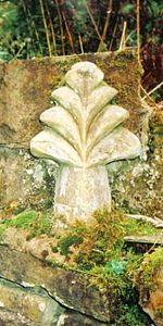
[34] It seems unlikely from the workmanship that the well's stone and 'cross' have anything to do with the old chapel, but one possibility is that it came from over the entrance door to Laigh Chapelton as the custom was for a Templar property to have the 'cross' symbol of the order displayed in such a fashion.
The remains of the abutments of a footbridge across the river are visible where the garden boundary hedge meets the Annick and Florence Miller remembers the bridge as still standing in the late 1920s.
This presumably Victorian or Edwardian feature would take people across to the area delineated by a small ha-ha, now thick with rhododendrons (R.ponticum), typically planted by estate owners.
"The contiguous ground of the park without the sunk fence was to be harmonized with the land within; and the garden in its turn was to be set free from its prim regularity, that it might assort with the wilder country without".
Most typically they are found in the grounds of grand country houses and estates and acted as a means of keeping the cattle and sheep out of the formal gardens, without the need for obtrusive fencing.
'Fossilised' linear bands of stone deposition in gardens which were part of this 'boundary' field suggest that the old Rig and furrow system was used hereabouts, however extensive modern ploughing has hidden the 'tell tale' signs.
Kingfishers have been seen just downstream and the estate's woodland policies and river contain, amongst others, tawny and barn owls, herons, mallard, ravens, rooks, treecreepers, buzzards, peewits or lapwings, roe deer, mink, moles, shrews, grey squirrels, hares, hedgehogs, foxes, badgers, pipistrelle bats and probably otters.
[46] A mill-wand was the rounded piece of wood acting as an axle with which several people would role a millstone form the quarry to the mill and to permit this the width of some early roads was set at a 'mill-wand breadth'.
The origin of the name is unclear, although 'furz' or furs' is old Scots for gorse or whin, however the existence of this small patch of fenced off land may be linked to the reference in Thomson's 1832 map to a fold, either for sheep or cattle.
[49] It could have been a pen for strayed stock or be connected with the tolls on the turnpike in some way or a 'stell', the Scot's word for a partial enclosure made by a wall or trees, to serve as a shelter for sheep or cattle.
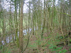
It was close to a small burn running from Water Plantation, above Stewarton, in a sheltered glen, typical of early religious settlements and the Kirkhill itself, which was wooded in 1858, is an excellent viewpoint.
[50] The plethora of religious names in this area – the Kirkmuirs, Kirkhill, Lady Moss, High Cross, Canaan and the Kilbrides, suggest that at some point in the distant past a pre-Christian and Christian site was located here.
Mr. Cunningham of Lainshaw built a handsome house over the well in 1833 and appointed a keeper to take care of it as the mineral water was of some value owing to healing properties attributed to it.
The ill-feeling seems to have spread into the next generation for James records that John has cut 'march' trees down in the past and has thrown thorns and brambles from the march into the High Chapeltoun's hayfields.
The march dyke is clearly marked on the 1885 OS map, following the course of the bank above the water meadow from the riverside and then running up as a 'v' shape towards High Chapeltoun before coming back down to join the lane near the Chapel mound.
Aiton in 1811 mentions "a curious notion that has long prevailed in the County of Ayr, and elsewhere, that the wool of sheep was pernicious to the growth of thorns" (hawthorn or whitethorn and blackthorn or sloe).
[64] Close to the cists site is the Mound Wood on Kennox Moss, an oval shaped artificial structure made of piled turf and surrounded by a well constructed drystone wall.
The soil in these parts is not sandy and the land ownership may very well be the explanation for the origin of the placename given the connection between the Sandylands or Sandilands family and the former Knights Templar estates.
Limekilns seem to have come into regular use about the 18th century and were located at Stacklawhill, Haysmuir, Bonshaw, High Chapeltoun, Bloomridge (Blinridge in 1828), Gillmill, Sandylands (now Bank End) and Crossgates.
The Gallery of Modern Art (GOMA) is a neo-classical building in Royal Exchange Square in the Glasgow city centre, which was built in 1778 as the townhouse of William Cunninghame of Lainshaw, a wealthy tobacco lord.