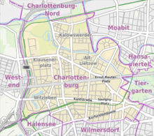
Charlottenburg
Its historic core, the former village green of Alt Lietzow, is situated on the southern shore of the Spree River running through the Berlin glacial valley.
Charlottenburg also borders on the district of Halensee in the southwest, as well as on Moabit, Hansaviertel and Tiergarten (all part of the Mitte borough) in the east and on Schöneberg in the southeast.
Within the Margraviate of Brandenburg, on the land occupied by present-day Charlottenburg, there were three settlements in the late Middle Ages: the farmsteads Lietzow (pronounced leat-tsow) south of the Spree and Casow (pr.
Lietzow (also called Lietze, Lutze, Lutzen, Lütze, Lützow, Lusze and Lucene) was first documented in 1239, when the Ascanian margraves John I and Otto III of Brandenburg founded the Benedictine Sankt Marien nunnery in nearby Spandau.
[2] From old field names, it is believed that a third medieval settlement on Charlottenburg territory, Glienicke, arose in the area of the present day streets Kantstraße, Fasanenstraße, Kurfürstendamm and Uhlandstraße at the former Gliniker Lake.
In the course of the Protestant Reformation, Elector Joachim II Hector of Brandenburg confiscated the monastic estates in 1542 and finally had the nunnery dissolved in 1558.
In 1695, Sophia Charlotte of Hanover received Lietzow from her husband, Elector Frederick III of Brandenburg, in exchange for her estates in Caputh and Langerwisch near Potsdam.
After he had crowned himself Frederick I, King in Prussia, the Lützenburg castle was extended into a stately building with a cour d'honneur.
Berliners seeking leisure and entertainment came by boat, by carriage and later by horse-drawn trams, above all to a large amusement park at the shore of the Spree river called Flora, that went into bankruptcy in 1904.
At the same time industrial companies like Siemens & Halske and Schering erected large factories in the north-east, at the border with the Moabit district of Berlin.
In the course of industrialization in the 19th century, much of Charlottenburg was incorporated in a network of streets laid out in the Hobrecht-Plan in an area that came to be known architecturally as the Wilhelmine Ring.
Artists like Alfred Döblin, Otto Dix, Gottfried Benn, Else Lasker-Schüler, Bertolt Brecht, Max Liebermann, Stefan Zweig and Friedrich Hollaender socialized in the legendary Romanisches Café at the Kaiser Wilhelm Memorial Church.
The area around Charlottenburg's Kantstrasse is Berlin's Chinatown in the West, with a high concentration of Asian shops, gastronomy and inhabitants.