Charyn Canyon
[1] It is part of the Charyn National Park established on 23 February 2004 and is located within the territory of the Uygur, Raiymbek, and Enbekshikazakh Districts of the Almaty Region.
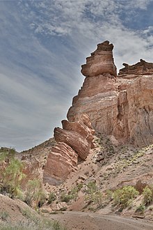
The geological formation of the canyon consists of sedimentary red sandstone that has been subject to the "atmogenic process", defined as "atmospheric origin by condensation, wind action, or deposition from volcanic vapors".
[1] The canyon can be accessed from Almaty on the main road that passes through the villages Shelek, Baiseit, and Kokpek (at a distance of about 190 kilometres (120 mi)).
The Temirlik River originates in the peaks of the Ketmen range (from Kazakh - Ketpen-a chain of high mountains (in the East of Almaty region).
A canyon up to one and a half kilometers wide and a gorge up to 160 meters deep represent the middle part of the Temirlik River.
The picturesque canyon with pillars, winding corridors, and crevices is very similar to its "older brother", the Charyn canyon, and the green strip is tight framed by red rocks of low rock formations makes an extraordinary impression and creates a picture of a colorful wild corner of nature.
Marikovskiy assumed that in the tract lived people who found and processed iron ore. Popular adventure sports activities in the river include whitewater rafting and canoeing.
[1] In May 2021, the Kazakh Ministry of Ecology, Geology, and Natural Resources announced that efforts will be made to develop tourism in the Charyn Canyon region with an emphasis on historical heritage as well as ecotourism.
[7] In 2021, the Chair of the Kazakh National Geographic Society, Orman Nurbayev, along with project manager Zhanibek Alkeev, announced the addition of eco-toilets, gazebos, shade awnings, drinking fountains, and observation decks to the Charyn Canyon tourism area.
[8] In 2021, German researchers from the Max Planck Institute for Chemistry analysed samples from the canyon, producing a five-million-year "unbroken" geological record of rainfall and climate change in the region.