Cheesequake State Park
The state first acquired a 250-acre (100 ha) tract of farmland and a Civil War-era mansion from the Favier brothers in January 1938.
Additional lands were acquired over the next two years, and the Civil Conservation Corps, part of the Works Progress Administration, helped develop the property.
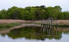
[14] The park's lowlands consist of freshwater and saltwater marsh and a tidal estuary near the mouth of Cheesequake Creek on the Raritan Bay.
It also includes hills of Northeastern hardwood forest, open fields, and a white cedar swamp.
[15] The park includes an interpretive center and five marked trails for both hiking and mountain biking that run throughout the wooded hills and across long wooden bridges across marshland.