Chennai district
[6] Much of the district's population descended from its settlements in the 1st century CE to the Middle Ages, but the diversity has grown much since then.
It is situated on the northeastern corner of Tamil Nadu along the Coramandel coast, a region bounded by the Bay of Bengal and is surrounded inland by the districts of Tiruvallur, Kanchipuram and Chengalpattu.
It lies between 12°59' and 13°9' of the northern latitude and 80°12' and 80°19' of the eastern longitude at an average altitude of 6 metres above sea level on a 'sandy shelving breaker swept' beach.
[10] The terrain is very flat with contours ranging from 2 m to 10 m above mean sea level with a few isolated hillocks in the southwest beyond the district limits at St. Thomas Mount, Pallavaram and Tambaram.
The district falls under Seismic Zone III indicating a moderate risk of earthquake.
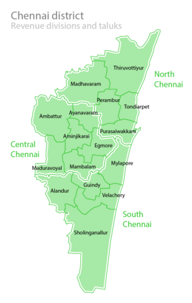
[15] In 2013, five taluks on the district were split to create five new ones: Velachery, Purasawalkam, Ayanavaram, Aminjikarai and Guindy.
[16] In January 2018, the state government announced that the district will be expanded to match the boundaries of the Greater Chennai Corporation.