In the Seattle City Clerk's Geographic Indexing Atlas, Cherry Hill is designated as the Minor neighborhood of the Central Area.
The highest point of elevation in Cherry Hill is 420 feet above sea level at the broadcast towers on East Madison Street.
[7] The name Cherry Hill was suggested by city councilmember Harlan Edwards in 1959 to describe the area for an Urban Renewal Project bounded by Cherry and Yesler Streets and 17th and 23rd Avenues, which includes Squire Park.
[16] The enduring nature of both the Cherry Hill and Squire Park neighborhood names may be explained by advantages of each.
Squire Park has the advantage of historical continuity and usage in property records, although this only applies for the region between Cherry and Alder Streets.
1909 Seattle map with the area currently known as Cherry Hill designated as Renton Hill.
View of Capitol Hill and Cherry Hill neighborhoods, looking east along Union Street. Cherry Hill resides to the east and south of Capitol Hill, equivalent to behind and to the right in this view. Cherry Hill landmarks visible include the three broadcast towers at Madison Street and 18th Ave, the Temple De Hirsch Sinai with its gray conical frustum in the center of the photo, and the Church of the Immaculate Conception at Marion St and 18th Ave with its two white towers near the right of the photo.
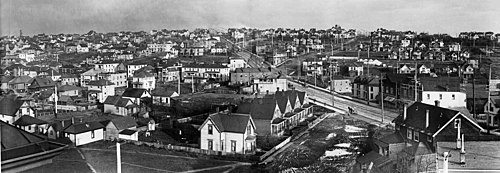
View of Cherry Hill circa 1905. At that time it was called either Second Hill or Renton Hill. Running diagonally through the image from bottom-right to top-left is Madison Street. Intersecting Madison Street in the center of the image and running to the top-right is Union Street. The cupola of the original T. T. Minor School is visible at the crest of the hill between Madison and Union Street. The original school building was razed and replaced with the current one in the 1940s. The current-day location of the broadcast towers would be at the top of Madison Street in this photo.