Chetwynd, British Columbia
Chetwynd /ˈtʃɛtwɪnd/ is a district municipality located in the eastern foothills of the Rocky Mountains, in northeastern British Columbia, Canada.
Situated on an ancient floodplain, it is the first town eastbound travellers encounter after emerging from the Rockies along Highway 97, and acts as the gateway to the Peace River Country.
[4] Once known as Little Prairie, the community adopted its name in honour of provincial politician Ralph Chetwynd, just prior to its incorporation, in 1962.
A rail line branches-off in three directions: northward to Fort St. John, east to Dawson Creek, and west through the Rockies to Prince George.
Chetwynd is a member municipality in the Peace River Regional District and, as of 2021[update], is represented in provincial politics by BC United MLA Mike Bernier (elected in 2013).
As the area's natural resource potential became more apparent, a highway was planned in the late 1940s from the British Columbia Interior to the northern side of the Rocky and Omineca Mountains.
Its load included pipe to symbolize natural gas development, steel railway track for the extension of the rail line, box cars for grain and lumber, and a truck representing freight hauling along the Alaska Highway.
In 1960, the Chetwynd Waterworks District expanded its mandate to include garbage disposal, fire protection, and street lighting.
[9] Growth continued in the 1960s when the town served as the rail-to-truck transshipment point for delivering workers and supplies to the construction site of the W. A. C. Bennett Dam in nearby Hudson's Hope.
[13][14][15][16][17] On 4 December 1996, Chetwynd's boundaries were expanded to include 49 square kilometres (19 sq mi) of forested land and industrial properties.
[18] Most of this came from moving the northern border up 210 metres (690 ft) over Ol' Baldy Ridge to create a community forest, a concept which originated from a Chetwynd Secondary School proposal in 1980 for a fitness trail.
[19][20] Carved out of an ancient floodplain, the small terrace upon which Chetwynd is situated lies in the northern foothills of the Rocky Mountains.
Meanwhile, the Centurion Series—which lies south of the highway—is a poorly drained soil with a dark-brown peaty surface material consisting of decomposed leaves and mosses.
[21][22] The town is surrounded by forested hills but the prairies of the Peace River Country begin here and continue eastward into Alberta.
[26] The region also contains moose, whose numbers have increased due to improved habitats caused by cutting down trees for the logging industry.
The area surrounding Chetwynd was affected by a pine beetle infestation, which caused timber mills to reduce their operations in the region.
The primary ethnic groups in Chetwynd were reported as: English (23.1%), Scottish (20.4%), German (17.8%), Irish (16.5%), French (12.5%), Métis (9.7%), Norwegian (9%), Canadians (8.4%), and First Nations (5.9%).
These rural residents are mostly cattle, sheep, and bison ranchers and use the town as a transportation hub to ship products via highways or rail.
[34] Since then, the economy has rebounded with increased oil, gas and mineral exploration, tourist marketing of the area's outdoor recreational activities and chainsaw carvings program, new and re-opened coal mines, and wind farm construction.
Rail lines enter Chetwynd from three directions: from Fort St. John in the north, from Dawson Creek in the east, and from Prince George in the south.
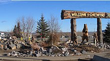
[49] A statue of a lumberjack entitled "Chetwynd, the Little Giant of the Great Peace", measuring 2.7 metres (8 ft 10 in) tall and located alongside the highway, has stood in the town since 1967.
The statue has been periodically altered by replacing the axe with other accessories, such as a lasso, rifle, gold pan and pitchfork, or dressed in other outfits, like a Santa suit.
[5][50] For outdoor recreation, a community forest on Mount Baldy provides residents with trails for walking, hiking, cycling, and cross-country skiing close to home.
For many years, they rebroadcast pre-recorded content to Chetwynd and surrounding communities via a telecommunications tower on nearby Wabi Mountain.
Chetwynd's community television station, CHET-TV channel 55, began broadcasting on 8 March 2000, in a ceremony attended by Adrienne Clarkson, then Governor General.
[54] The Chetwynd Communications Society also owns a series of low-powered repeaters that rebroadcasts selected Canadian and American stations via satellite.
[55][56] Two periodicals covered local news: the weekly newspaper Chetwynd Echo and the biweekly newsletter Coffee Talk Express.
It also maintains the sewer, water, local road, sidewalk, street lighting, animal control, building inspection, park, and recreation services.
The city also partially funds a ten officer Royal Canadian Mounted Police detachment, which covers the municipality and nearby rural communities.
[67] Chetwynd is located in the Prince George—Peace River—Northern Rockies riding which sends a member of parliament to the federal House of Commons.