Chicago Portage
Connecting these two great water trails meant comparatively easy access from the mouth of the St. Lawrence River on the Atlantic Ocean to the Rocky Mountains, and the Gulf of Mexico.
[1] Mud Lake could be wet, dry, marshy, or frozen, depending on the season and the weather, making it at times a difficult, albeit very valuable, transportation route.
[1] The Chicago Portage allowed easy access, by boat, to almost all of North America, from the mouth of the St Lawrence River to the Rocky Mountains and the Gulf of Mexico.
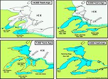
Since at this time most long-distance travel for trade purposes was via water, it is likely that during this Woodland period the Chicago Portage was first regularly used.
[7], p 24 During all of this time early Native Americans found the Chicago Portage to be a convenient transportation route between the Great Lakes region and the Mississippi River in the interior.
In May of that year the group, consisting of Louis Jolliet, Father Jacques Marquette, and five voyageurs set out on their voyage of discovery.
The Joy that we felt at being selected for This Expedition animated our Courage, and rendered the labor of paddling from morning to night agreeable to us.The explorers found the Mississippi River, explored it,[10] and then returned to Michilimakinac by a different route on the advice of Native Americans they had encountered along the way, who told them that there was a better way to return to Lake Michigan.
Accounts from soldiers stationed at Fort Dearborn, at the mouth of the Chicago River, describe a passage from west to east.
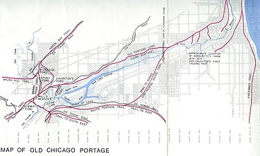
At the east end of the marsh they portaged their boats, equipment, and supplies over a low rise of land that was the St Lawrence River continental divide.
[12] If water levels in the portage were low, passage was difficult, in part due to the soft or waterlogged ground.
In 1818 Gurdon Hubbard, then 16 years old and traveling with a “brigade” of voyageurs as an indentured clerk, crossed the Portage from East to West and left an account in his memoirs.
They traveled down the South Branch of the Chicago River and pulled their boats over the St Lawrence Continental Divide into Mud Lake where the water was deep enough to float them.
Then … Other members of the crew carried the boats’ cargo, across the seven-mile-long land trail to the Des Plaines River.
The map also shows the Old Portage Long trail that was used when there was insufficient water in Mud Lake to allow traverse by canoe.
The site is the only part of the Portage that remains in a natural and protected state more or less as it existed when in use by Native Americans and the Europeans who came after them.
During the period 1892-1900 the original channel of the river was straightened, cutting off the part that the Jolliet and Marquette party used to reach the west end of the portage.
[15] This aerial photo shows the Des Plaines River and the area around the Portage Historic Site as they exist today (2024).
The Chicago Portage National Historic Site is outlined in red and the map shows the entrance to Mud Lake and the West End Landing.
Further proof that the original course of the Des Plaines River is as shown comes from the third map, one of many from the Knight and Zeuch study of the Chicago Portage.