Chicago River
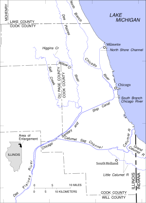
[7] Its three branches serve as the inspiration for the Municipal Device,[8][9][10] a three-branched, Y-shaped symbol that is found on many buildings and other structures throughout Chicago.
[14] It then flows southward, paralleling the shore of Lake Michigan, through wetlands, the Greenbelt Forest Preserve and a number of golf courses towards Highland Park, Illinois.
[15] South of Highland Park the river passes the Chicago Botanic Gardens and through an area of former marshlands known as the Skokie Lagoons.
From the west, the Middle Fork arises near Rondout, Illinois and flows southwards through Lake Forest and Highland Park.
[16] The third tributary, the West Fork, rises near Mettawa and flows south through Lincolnshire, Bannockburn, Deerfield, and Northbrook, meeting the North Branch at Morton Grove.
[17] In recognition of the work of Ralph Frese in promoting canoeing on and conservation of Chicago-area rivers, the forest preserve district of Cook County, Illinois has designated a section of the East Fork and North Branch from Willow Road in Northfield to Dempster Street in Morton Grove the Ralph Frese River Trail.
[27] From Goose Island the North Branch continues to flow south east to Wolf Point where it joins the main stem.
The river turns slightly to the south west between Michigan Avenue and State Street, passing the Trump International Hotel and Tower, 35 East Wacker, and 330 North Wabash.
Turning west again the river passes Marina City, the Reid, Murdoch & Co. Building, and Merchandise Mart, and 333 Wacker Drive.
It provides a linear, lushly landscaped park intended to offer a peaceful escape from the busy Loop and a tourist attraction.
Notable buildings that line this stretch of the river include the Boeing Company World Headquarters, the Civic Opera House, the Chicago Mercantile Exchange, Union Station and Willis Tower.
[35] The river turns to the southwest at Ping Tom Memorial Park where it passes under the Chicago Landmark Canal Street railroad bridge.
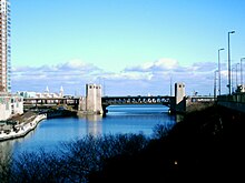
The river turns westward where it is crossed by the Dan Ryan Expressway; these immovable bridges have a clearance of 60 feet (18 m) requiring large ships that pass underneath to have folding masts.
The original West Fork of the South Branch, which before 1935[39] led towards Mud Lake and the Chicago Portage, has been filled in; a triangular intrusion into the north bank at Damen Avenue marks the place where it diverged from the course of the canal.
The United States Geological Survey monitors water flow at a number of sites in the Chicago River system.
The first non-native to re-settle in the area may have been a trader named Guillory, who might have had a trading post near Wolf Point on the Chicago River in around 1778.
Jean Baptiste Point du Sable is widely regarded as the first permanent resident of Chicago; he built a farm on the northern bank at the mouth of the river in the 1780s.
[48] The earliest known record of Pointe du Sable living in Chicago is the diary of Hugh Heward, who made a journey through Illinois in the spring of 1790.
[52] In 1803, Fort Dearborn was constructed on the bank opposite what had been Point du Sable's settlement, on the site of the present-day Michigan Avenue Bridge.
As Chicago grew, this allowed sewage and other pollution into the clean-water source for the city, contributing to several public health problems, like typhoid fever.
[64] Finally, in 1900, the Sanitary District of Chicago, then headed by William Boldenweck, completely reversed the flow of the main stem and South Branch of the river using a series of canal locks, increasing the river's flow from Lake Michigan and causing it to empty into the newly completed Chicago Sanitary and Ship Canal.
[65] Through the 1980s, the river was quite dirty and often filled with garbage; however, during the 1990s, it underwent extensive cleaning as part of an effort at beautification by Chicago Mayor Richard M.
Frantic if disordered rescue attempts ensued and early versions of what may be regarded as trauma teams formed to address the shocking scene.
The site on the south bank at the southeast end of the La Salle Street Bridge is now the location of a memorial first dedicated in 1989.
[86] In 2009 First Lady Michelle Obama, a Chicago native, inspired by the river tradition, requested that the water in the White House fountains be dyed green to celebrate Saint Patrick's Day.
"[89] The southwest bridgehouse of the DuSable Bridge (Michigan Avenue) serves as a museum on the river, its history, its challenges, and its renaissance.
[90] In October 2019, Chicago Tribune cultural arts writer Steve Johnson profiled the museum, calling its gear room where the DuSable Bridge mechanics can be viewed "a little chamber of heaven for infrastructure nerds".
A December 26, 2012 report revealed that Chicago District navigation infrastructure did receive significant impacts from Hurricane Sandy with some areas experiencing severe shoaling.
[5] The same report noted that the low Great Lakes levels were drought-induced, caused by a very hot, dry summer and a lack of a solid snowpack in the winter of 2012.
David St. Pierre, executive director of the Metropolitan Water Reclamation District of Greater Chicago warned the low lake levels were nearing a point of real concern.