Choquequirao
Choquequirao (possibly from Quechua chuqi metal, k'iraw crib, cot)[1][2][3][4] is an Incan site in southern Peru, similar in structure and architecture to Machu Picchu.
Choquequirao at an elevation of 3,050 metres (10,010 ft) [5] is in the spurs of the Vilcabamba mountain range in the Mollepata district, Anta province of the Cusco Region.
Other sites in this area are Sayhuite, Machu Picchu, Chachabamba (Chachapampa), Choquesuysuy (Chuqisuyuy), and Guamanmarca (Wamanmarka); all of which share similar architectural styles with Choquequirao.
Colonial documents also suggest that Tupac Inca ruled Choquequirao since his great grandson, Tupa Sayri, claimed ownership of the site and neighboring lands during Spanish colonization.
According to the Peruvian Tourism Office, "Choquequirao was probably one of the entrance check points to the Vilcabamba, and also an administrative hub serving political, social, and economic functions.
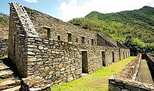
Its urban design has followed the symbolic patterns of the imperial capital, with ritual places dedicated to Inti (the Incan sun god) and the ancestors, to the earth, water, and other divinities, with mansions for administrators and houses for artisans, warehouses, large dormitories or kallankas, and farming terraces belonging to the Inca or the local people.
The Prefect of the Province of Apurimac, J.J. Nuñez, encouraged Hiram Bingham to visit the 'Cradle of Gold', in order to discover any Incan treasure.
The main structures, such as temples, huacas, elite residences, and fountain/bath systems are concentrated around two plazas along the crest of the ridge, which encompass approximately 2 km2 and follow Inca urban design.
This seems as such due to evidence showing that the only entrance to the platform was through a double-jam doorway, which functioned to control access to the sacred space.
[25] Other features of the ceremonial center include structures that mark the direction of certain solar events, such as when the June and December solstice sun rises and sets.
This belief is held based on their strong resemblance to those at sector II of Llaqtapata and because there are numerous water channels leading to that portion of the plaza.
[25] Overall, it seems as though the site was chosen, as Machu Picchu was, for its sacred geographical location, and was designed to facilitate ritual and ceremonial activity.
Design, construction style, and cultural parallels support that these sectors were tightly intertwined with Choquequiaro and the Inca at some point in their history.
Instead, the entrances and corners were shaped from quartzite, and the walls were made of ashlar and plastered with clay and then painted in a light orange color.
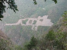
[8] One recent discovery for example, uncovered a scene laid into the stone terraces with white quartzite depicting several llamas loaded with cargo standing by their handlers.
The common trailhead begins at the village of San Pedro de Cachora,[34] which is approximately a 4-hour drive from Cuzco, along the Cusco-Abancay route.
[35] Carlos Canales, president of the National Chamber of Tourism (Canatur) believes that in the first year of operation the Choquequirao cable car will receive 200,000 tourists, which will generate an income of US$4 million, with the average visitor paying US$20 per ticket.