Ciliwung
The Ciliwung (often written as Ci Liwung as the "ci" prefix simply translates as "river"; also as Tjiliwoeng in Dutch, Sundanese: ᮎᮤᮜᮤᮝᮥᮀ) is a 119 km long river in the northwestern region of Java where it flows through two provinces, West Java and the special region of Jakarta.
The natural estuary of the Ciliwung, known as the Kali Besar ("Big River"), was an important strategic point for trade in the precolonial and colonial periods and was instrumental in the founding of the port city of Jakarta, but has been lost from a reorganization of the watercourse of the rivers around the area into canals.
In general, the geology the upstream of Ciliwung basin is dominated by Tuffaceous Breccia and older deposits of lahar and lava.
With such topographical, geological, and hydrological features, the Ciliwung River is often overflowing and inundating parts of Jakarta.
[1] The natural flow of the Ciliwung was diverted into canals by the Dutch during the early settlement of Jakarta (then named Batavia).
Today this canal, which is now located on the south side of Jalan Tol Pelabuhan, was filled with slum settlement due to careless planning after the independence period.
The water is diverted to the west of the city through Pasar Rumput, Dukuh Atas going northwest to Karet Kubur, and continues to Tanah Abang, Tomang, Grogol, Pademangan, and ends at Muara Angke.
[4] On December 19, 2013, a contract to build water tunnel(s) to the East Flood Canal from the Ciliwung with a minimum capacity of 60 cubic meters per second was signed by the Public Works Ministry.
[1] In the early 16th century, the Ciliwung was an important means of transportation from the fortified city of Pakuan Pajajaran, the capital of the Hindu Sunda Kingdom.
To protect Sunda Kelapa from the Islamic Sultanate of Cirebon and Demak, Prabu Surawisesa (recorded by the Portuguese as Samian) was instructed by the king to sign a peace treaty with the Portuguese to trade in pepper in exchange for permission to build a fort to protect the main port of Sunda Kalapa.
The padrão of Sunda Kelapa was found by Fatahillah, commander of the Sultanate of Demak, and fell into the Ciliwung without any ceremony.
The largest canal that flows through the middle of Batavia was named Kali Besar or Dutch Grote Rivier ("Big River").
Small boats sailed along Ciliwung to transport goods from warehouses close to Kali Besar to ships anchored at the port.
The length of the ditch increased to 1,350 m (1827) from the mouth of the river due to the accumulation of sand and mud and what more with the earthquake in January 1699[9] A Ciliwung tributary that empties into the ocean was used for ship entrance into the castle from the canals to Waterpoort.
Water from the Ciliwung was initially stored in a reservoir (waterplaats or aquada) near Fort Jacatra, north of the city.
[11] Despite the attempt, seasonal flooding occurred where the Ciliwung forced its water to flow back to its old tributary, which was still happening around 1725.
The construction of the Gunung Sahari Canal caused frequent flooding in the area along the Noordwijk (now Jalan Ir.
[10] The part of the Ciliwung that flows straight from Harmoni to the north used to be a private river with toll payments for those who wanted to pass through it.
In 1648, Beng Gan received permission from the company to build this river and collected toll payments from sampans that passed through.
[13] A coordination meeting on January 20, 2014, among the Ministry of Public Works, Ministry of Environment, Jakarta Governor, Bogor Mayor, Bogor Regent, and Ciliwung-Cisadane Rivers Control Office agreed to build Ciliwung to Cisadane River to ease Ciliwung debit when Cisadane is not in flood condition.
Culture in the Bogor area is mainly Sundanese, such as can be observed in traditional dances, the Ketuk Tilu, or the Jaipongan which is modern, sensual, and full of spirit.
Informal settlements or slums flourished on the banks of the Ciliwung, increasing the amount of waste and reducing the surface area of the river.
In 2012, the government of Indonesia announced a 20-year plan to clean up the Ciliwung, which kicked off with a $10 million restoration project that will include the construction of a waste processing facility in 2013[17] and an education centre for riverside communities.
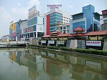
Ex-Governor Basuki Tjahaja Purnama also plans to turn parts of the Ciliwung riverbank into a tourist site.