Cirrocumulus cloud
Unlike other high-altitude tropospheric clouds like cirrus and cirrostratus, cirrocumulus includes a small amount of liquid water droplets, although these are in a supercooled state.
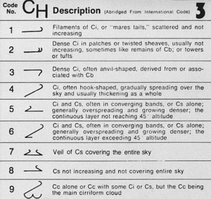
[6] Cirrocumulus is a cloud of the stratocumuliform physical category that shows both stratiform and cumuliform characteristics and typically appears as white, patchy sheets with ripples or tufts without gray shading.
[5] These often are organized in rows like other cumuliform and stratocumuliform clouds, but since they are so small, cirrocumulus patches take on a finer appearance, sometimes also referred to colloquially as "herringbone" or as a "mackerel sky".
Cirrocumulus generally occur at higher altitudes than altocumulus, thus the "cloudlets" appear smaller, as they are more distant from observation at ground level.
If it forms in patches with cirrus or cirrostratus and the clouds spread across the sky, it usually means rain in 8–10 hours (can be more if the front is slow-moving).