Cirrus cloud
In the Earth's atmosphere, cirrus are usually formed when warm, dry air rises, causing water vapor deposition onto mineral dust and metallic particles at high altitudes.
Cirrus clouds can form from the tops of thunderstorms and tropical cyclones and sometimes predict the arrival of rain or storms.
Optical phenomena, such as sun dogs and halos, can be produced by light interacting with ice crystals in cirrus clouds.
Cirrus are wispy clouds made of long strands of ice crystals that are described as feathery,[1] hair-like, or layered in appearance.
Ice crystals in the clouds cause them to usually appear white, but the rising or setting sun can color them various shades of yellow or red.
[5] Cirrus comes in five visually-distinct species: castellanus, fibratus, floccus, spissatus, and uncinus:[2] Each species is divided into up to four varieties: intortus, vertebratus, radiatus, and duplicatus:[10] Cirrus clouds often produce hair-like filaments called fall streaks, made of heavier ice crystals that fall from the cloud.
Polar regions, on the other hand, have significantly less cirrus cloud cover, with some areas having a yearly average of only around 10% coverage.
Particles gathered by research aircraft from cirrus clouds over several locations above North America and Central America included mineral dust (containing aluminum, potassium, calcium, iron, and silicon), metallic particles in elemental, sulfate and oxide forms (containing sodium, potassium, iron, nickel, copper, zinc, tin, silver, molybdenum and lead), possible biological particles (containing oxygen, carbon, nitrogen and phosphorus) and elemental carbon.
The authors concluded that mineral dust contributed the largest number of ice nuclei to cirrus cloud formation.
[22] At latitudes of 65° N or S, close to polar regions, cirrus clouds form, on average, only 7,000 m (23,000 ft) above sea level.
[23] The jet stream, a high-level wind band, can stretch cirrus clouds long enough to cross continents.
[26][27] However, research suggests that cirrus clouds more commonly form on mineral dust or metallic particles rather than on organic ones.
[29]) A large shield of cirrus and cirrostratus typically accompanies the high altitude outflowing winds of tropical cyclones,[28] and these can make the underlying bands of rain—and sometimes even the eye—difficult to detect in satellite photographs.
[31] The anvil cloud takes its shape because the temperature inversion at the tropopause prevents the warm, moist air forming the thunderstorm from rising any higher, thus creating the flat top.
The exhaust can trigger the formation of cirrus by providing ice nuclei when there is an insufficient naturally-occurring supply in the atmosphere.
[20] A large number of cirrus clouds can be a sign of an approaching frontal system or upper air disturbance.
[20] When a jet streak creates a large arc of cirrus, weather conditions may be right for the development of winter storms.
In the early 1870s the president of Belén College in Havana, Father Benito Viñes, developed the first hurricane forecasting system; he mainly used the motion of these clouds in formulating his predictions.
[44] When they are thin and translucent, the clouds efficiently absorb outgoing infrared radiation while only marginally reflecting the incoming sunlight.
[49] Metallic particles from human sources act as additional nucleation seeds, potentially increasing cirrus cloud cover and thus contributing further to climate change.
[50] Cirrus cloud thinning has been proposed as a possible geoengineering approach to reduce climate damage due to carbon dioxide.
The 2021 IPCC Assessment Report expressed low confidence in the cooling effect of cirrus cloud thinning, due to limited understanding.
Lidar (laser-based radar) gives highly accurate information on the cloud's altitude, length, and width.
[53] NASA's Moderate-Resolution Imaging Spectroradiometer gives information on the cirrus cloud cover by measuring reflected infrared radiation of various specific frequencies during the day.
[53] Particle Analysis by Laser Mass Spectrometry (PALMS)[b] is used to identify the type of nucleation seeds that spawned the ice crystals in a cirrus cloud.
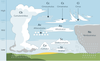
Three additional genera usually form in the low-altitude range, but may be based at higher levels under conditions of very low humidity.
These are sometimes classified separately as clouds of vertical development, especially when their tops are high enough to be composed of supercooled water droplets or ice crystals.
[74] These clouds do not last long, and they tend to change into cirrus because as the water vapor continues to deposit on the ice crystals, they eventually begin to fall, destroying the upward convection.
[80] Near the end of its mission, the Phoenix Lander detected more thin clouds close to the north pole of Mars.
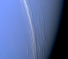
When Jupiter's South Equatorial Belt disappeared, one hypothesis put forward by Glenn Orten was that a large quantity of ammonia cirrus clouds had formed above it, hiding it from view.