Civil parishes in Ireland
Their use as administrative units was gradually replaced by Poor Law Divisions in the 19th century, although they were not formally abolished.
[dubious – discuss] Following the Norman invasion of Ireland, the Anglo-Norman barons retained the tuath, later renamed a parish or manor, as a unit of taxation.
It proved inaccurate, and in 1656–58 the Down Survey was conducted, using physical measurements to make as accurate a map as was possible at the time of townlands, parishes and baronies.
[7][8] For poor law purposes district electoral divisions replaced the civil parishes in the mid-nineteenth century.
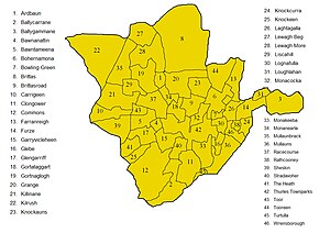
Townlands are the smallest land unit in Ireland, and were the most precise address that most rural people had until the 2015 introduction of postcodes.
[10] A Tudor statute, renewed in 1695 by the Irish parliament, said that land should be granted in each parish for a resident Protestant schoolmaster.
[13] At the time of the 1861 census there were 2,428 civil parishes in Ireland (average area 34.8 square kilometres (13.4 sq mi; 8,600 acres)).
[14] Later "parish councils" which gained a modicum of official recognition were based on Roman Catholic parishes: first those recognised by the Congested Districts Board for Ireland; and later those recognised by Part VIII of the Local Government Act 1941, mainly set up by Muintir na Tíre and operating during the Second World War Emergency.
[17] Until 1981 the Republic's official census reports included the populations of civil parishes in and near cities, because "numerous requests" were still being made for them.