Clackline Bridge
The mainly timber bridge has a unique curved and sloped design, due to the difficult topography and the route of the former railway.
The bridge has undergone various improvement and maintenance works since then, including widening by three metres (10 ft) in 1959–60, but remained a safety hazard, with increasing severity and numbers of accidents through the 1970s and 1980s.
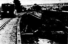
[1]: 8 The double tracks of the Eastern Railway, which linked Perth and Northam until its removal in 1981,[1]: 7 passed between piers 16 and 17.
The 14-metre-long (46 ft) span over the railway alignment was originally supported on four 610-by-190-millimetre (24.0 by 7.5 in) steel beams, weighing 41 kilograms (90 lb) each.
Some of the connecting bolts in the structure have been replaced, and a concrete approach slab was installed at the western end.
[1]: 10 The settlement of Clackline began as a stopping point on the Spencers Brook to Northam section of the Eastern Railway line, which opened on 13 October 1886.
[1]: 4 In March 1934, torrential rain caused widespread flooding in the Wheatbelt, affecting Northam, Toodyay, York, Beverley, and surrounding areas.
[6] The Main Roads Department had been considering completing the remaining improvements in November 1933, but the flooding made the situation more urgent.
[1]: 4–5 Main Roads engineer Ernest Godfrey completed a design for the Clackline Deviation, a single bridge over the waterway and railway, in August 1934.
This shift increased the curve radius, but required "the destruction of some well developed pine trees inside the old boundary fence of the [Clackline School] playground".
[1]: 5 Construction was undertaken by Main Roads Department day labourers, starting in January 1935,[7] as part of an unemployment relief works program.
[1]: 5–6 The bridge was completed less than one year after construction began, which would later be described as "a considerable achievement of the management and workforce for such a complex structure".
[1]: 5–6 Within two decades the bridge was considered a safety hazard, due to increased traffic volume, speed, and truck sizes.
The approaches to the bridges were widened, new piers were erected either side of the railway span, and eight new girders were installed – six of which were part of the previous Causeway structure.
The 1980s saw the closure and removal of the Perth–Northam railway line, as well a number of major and sometimes fatal accidents involving prime movers.
Steel props were installed to support the bridge, and the substructure was repaired in 1995, which mainly involved replacing connecting bolts.
[2] By this time Great Eastern Highway's bypass of Clackline was being planned, but maintenance works continued to be undertaken as needed.