Geography of Mauritania
Mauritania, a country in the Western Region of the continent of Africa, is generally flat, its 1,030,700 square kilometres forming vast, arid plains broken by occasional ridges and clifflike outcroppings.
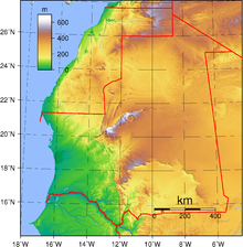
The scarps also separate a series of sandstone plateaus, the highest of which is the Adrar Plateau, reaching an elevation of 500 metres or 1,640 feet.
The plateaus gradually descend toward the northeast to the barren El Djouf, or "Empty Quarter," a vast region of large sand dunes that merges into the Sahara Desert.
Belts of natural vegetation, corresponding to the rainfall pattern, extend from east to west and range from traces of tropical forest along the Sénégal River to brush and savanna in the southeast.
Sand, varying in color and composition, covers 40 percent of the surface of the country, forming dunes that appear in all zones except the Senegal River Valley.
Its southern boundary corresponds to the isohyet (a line on the Earth's surface along which the rainfall is the same) that represents annual precipitation of 150 millimetres (5.9 in).
The administrative regions (formerly called cercles) of Tiris Zemmour in the north, Adrar in the center, and northern Hodh ech Chargui in the east, which make up most of the Saharan Zone, are vast empty stretches of dunes alternating with granite outcroppings.
In the western portion of the Saharan Zone, extending toward Nouakchott, rows of sand dunes are aligned from northeast to southwest in ridges from two to twenty kilometres wide.
Some mountainous areas with a water source support small-leafed and spiny plants and scrub grasses suitable for camels.
Large date palm plantations are found on the Tagant Plateau, and savanna grasses, brushwood, balsam, and spurge cover fixed dunes.
Farther south, particularly in Assaba and the northern portion of Guidimaka regions, rainfall is high enough to support forms of sedentary agriculture.
Almost all of the valley's economically active population engages in sedentary agriculture or fishing along the Senegal River and its main tributaries—the Karakoro, the Gorgol, and the Garfa.
From its source in Guinea, it flows north and west 2,500 kilometres (1,553 mi), reaching the Atlantic Ocean at Saint Louis, Senegal.
These floods cover the entire valley up to a width of 25 to 35 kilometres (16 to 22 mi), filling numerous lakes and sloughs (marigots) that empty back into the river during the dry season.
Prevailing oceanic trade winds from the Canary Islands modify the influence of the harmattan, producing a humid but temperate climate.
The peninsula is administratively divided between Western Sahara and Mauritania, with the Mauritanian port and railhead of Nouadhibou located on the eastern shore.
From this cape to the marshy area around the mouth of the Senegal River, the coast is regular and marked only by an occasional high dune.
[5] The climate has altered drastically since the onset of the prolonged drought in the 1960s, part of a recurrent pattern of wet and dry cycles common to Sahelian Africa.
Experts agree, however, that overgrazing, deforestation, denuding of ground cover around wells, poor farming methods, and overpopulation have aggravated the drought.
In Mauritania the isohyet indicating annual rainfall of 150 millimetres—considered the minimum for pastoralism—has shifted southward about 100 kilometres to a point well south of Nouakchott.
Loss of ground cover in the Sahelian Zone had driven animals and people southward in search of food and water and had given rise to new fields of sand dunes.
The government secured international help to stabilize the dune field around Nouakchott and planted 250,000 palm trees to create a barrier against the encroaching desert.