County Wicklow
The local tribe in the area were called Cualann and their chief, a man named Naithi was opposed to these Christian missionaries.
[7] A large number of early Irish saints male and female founded churches, monasteries and convents in Wicklow.
Among them were St. Kevin, St. Dagan, St. Ernan, St. Credan, St. Baotan and the holy women St. Cainnear, St. Ceoltigherna, St. Fledh, St. Tartinna, St. Coine and St.
During the Irish Rebellion of 1798, some of the United Irishmen insurgents took refuge in the Wicklow Mountains,[18] resulting in clashes between British forces and rebels commanded by Joseph Holt near Aughrim and later at Arklow.
It is bounded by four counties, Dublin to the north; Kildare and Carlow to the west; Wexford to the south; and the Irish Sea to the east.
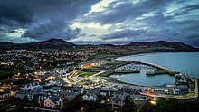
The county is named after the town of Wicklow, located approximately 50 kilometres (31 mi) south of Dublin, the capital city of Ireland.
[24] The Wicklow Mountains are centred on the Leinster batholith and are primarily composed of granite surrounded by an envelope of mica-schist and much older rocks such as quartzite.
Covering 1,500 square kilometres (580 sq mi), the Leinster batholith is the most expansive mass of intrusive igneous rock in Ireland or Britain.
[26] These metamorphosed from sandstone deposited in the deep waters of the primeval Iapetus Ocean during the Cambrian period (542-488 million years ago).
[29] The 117.5-kilometre (73.0 mi) River Slaney, which starts at Lugnaquilla, flows west and then south before reaching St George's Channel at Wexford town.
Ruins of the old village including buildings, fences and farm machinery can be seen during droughts when water levels in the reservoir diminish.
Wicklow Head is the county's most prominent coastal headland, and is also the most easterly mainland point of the Republic of Ireland.
The county has roughly 37,500 hectares (93,000 acres) of wooded area, the 8th highest total forest cover in Ireland.
The economic tree line in the region is around 400 metres (1,300 ft), above which hill farming and blanket bog dominates.
[38] In terms of urban development, Wicklow County Council imposes the most stringent planning restrictions in Ireland.
The primary justification for these restrictions is to avoid one-off housing or other poorly planned developments which could put a strain on the county's infrastructure and degrade its natural environment.
[44] The coastal region of County Dublin immediately to the north is the driest location in all of Ireland as a result of the rain shadow created by the mountains.
[45] Easterly winds can occur between February and May, and are often associated with extreme snowfall events such as the 2018 "Beast from the East" and the "Big Snow of 1947".
[46] Much of Wicklow is very vulnerable to heavy snowfall and the county is typically the hardest hit by such events, with some areas recording over 2 feet (61 cm) of snow.
[47] During the winter of 1947, residents of Rathdrum called upon the Irish Red Cross to drop them food parcels by plane as the village had been inaccessible by road for over a month due to heavy snow.
On 24 August 1986, during Hurricane Charley, 280 mm (11 in) of rain fell over a 24-hour period at Kippure on the Wicklow-Dublin border, the greatest daily rainfall total ever recorded in Ireland.
[61] The most densely populated areas of the county are concentrated in the northeast, with over 50 percent of Wicklow's residents living within 15 kilometres (9 mi) of the Dublin border.
[62] Many of the county's largest urban areas are clustered in this region along an axis stretching from Bray to Newtownmountkennedy, which incorporates Greystones, Delgany, Enniskerry, Kilmacanogue, Kilpedder and Kilcoole.
The county's interior is very sparsely populated, with only a few small settlements located in the foothills of the Wicklow Mountains such as Rathdrum, Laragh, Roundwood and Tinahely.
Asians were the second largest ethnic group, comprising 1.6% of the county's population, followed by mixed race or other backgrounds at 1.2%.
[65] According to the CSO report Urban and Rural Life in Ireland 2019, Wicklow (alongside Kildare) has the highest proportion of residents living in satellite towns.
[83] Sometimes the old thatched roof was kept in place underneath the sheets of galvanising to act as a layer of insulation and dampen the noise of heavy rain.
I Love You were shot in the Wicklow Mountains National Park while several scenes from other movies, from Barry Lyndon to Haywire, have been filmed in the county.
[85] Much of the television series Vikings, (Amazon Prime), was filmed at Ashford Studios in the county, particularly scenes that required a green screen for subsequent CGI work.
[89][90] Fate: The Winx Saga, announced by Netflix in 2019, was also shot in the county and based at Ardmore Studios, Bray.