Coen, Queensland
Download coordinates as: Coen is a rural town and coastal locality in the Shire of Cook, Queensland, Australia.
The community is quite busy, particularly in the dry season, with all tourists and visitors travelling the Peninsula Development Road up to the tip of Cape York having to pass through the town.
[3][4] The Coen district was first settled following the exploration of Cape York Peninsula by William Hann in 1872.
A government surveyor, A C Macmillan, with a group of engineers protected by a consignment of Native Police, blazed a track from Cooktown to the Palmer River goldfields in October 1873.
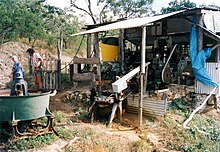
[5] In 1876, Robert Sefton found gold at the Coen River after leading a prospecting party into the interior of Cape York.
He built a log fort there for protection from any hostility from local Aboriginal groups and prospected for gold in the surrounding country.
About 500 miners flocked to the Coen field, but exploration further afield was not possible due to the danger of being attacked by local Aboriginal people.
In 1879, geologist Robert Logan Jack led a government-sponsored exploration of Cape York Peninsula.
[5] Due to the fierce resistance of local Aboriginal people, settlement on the McIvor and Coen Rivers only took a tentative hold during the early 1880s.
The Aboriginal people in the Coen district adapted to European settlement by moving onto the newly established cattle stations where they became stockmen and domestic labour.
In 1947, an extended family group was found by the police near the Archer River and brought into Coen.
They formed a community at the Stewart River on what is now Silver Plains Station, near the site of the Moojeeba township.
[5] The Great Northern mine continued operations until 1916 and produced some 52,000 troy ounces (1,600 kg) of gold before it closed.
[citation needed] As gold mining declined from around the 1930s, Coen still remained an important administrative and social centre for the surrounding Cape York communities.
However, the local protector opposed the proposal saying that:[5]"your suggestion to send these old people to Lockhart River is unthinkable.
[5] During World War II, Coen was an important part of the forward defence network.
The reserve was located south of the town on the Coen River between Oscar and Spring Creeks.
As well, until the 1960s, when the Weipa-Bamaga area was developed, Coen was the most northerly town on Cape York Peninsula.
Outstations belonging to the different groups in the Coen district include Stoney Creek, Langi, Port Stewart, Wenlock, Puntimu and Glen Garland.
[6] Today Coen provides services to the region, and is an important supply point on the long unpaved road leading to Weipa and other northern communities.
It is a popular stopping point for tourists driving to the tip of Cape York - the northernmost part of the Australian mainland.
It has an airstrip at Coen Airport (24 kilometres (15 mi) north of the town), public library, hotel/motel, guest house, two general stores and fuel outlets, hospital, post office, police station, camping grounds, primary school kindergarten, ranger base and more.
The wet season occurs from December to March and is characterized by frequent torrential downpours and high humidity.
This article contains text from "Aboriginal and Torres Strait Islander community histories: Coen".