Cogan House Covered Bridge
It was the only bridge on Larrys Creek that survived the flood of June 1889, and one of only a handful that were left intact in the county.
Although the bridge used to carry a steady flow of tannery and sawmill traffic, the clearcutting of the surrounding forests meant the end of those industries by the early 20th century.
Since then much of the surrounding area has reverted to second growth forest, and the one-lane bridge is now on a dead end road in a remote valley with little traffic.
[4][5] Its official name on the National Register of Historic Places (NRHP) is "Cogan House Covered Bridge".
In 19th-century Pennsylvania, lumber was an abundant resource for bridge construction,[16] but did not last long when exposed to weather and the elements.
[4] In 1850 a plank road was built in Lycoming County, from the mouth of Larrys Creek to the borough of Salladasburg, Pennsylvania.
Wagons of finished leather and raw hides came from and went to the English Center tannery via White Pine, seeking to avoid traffic on the plank road along the Second Fork.
[7] Because the ford was often impassable in winter or bad weather, or during high water,[18] a petition from the citizens of Cogan House Township for a bridge to be built was filed in September 1876.
The petition was read on September 30, 1876, and three viewers were appointed on November 3 to examine the site and report back.
After the framework was completed in the field, it was taken apart, loaded onto the same ox carts used to bring the logs to the mill, and taken to the bridge site.
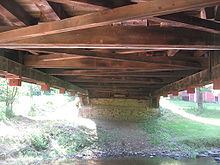
[7] The covered bridge rests on the original stone abutments, which have since been reinforced with concrete made of cement.
The upper part of the portals and the clapboard siding is made of pine boards, and stops 3 feet (0.9 m) below the roof line.
[8] After the flood the plank road was only reconstructed as far north as Salladasburg, so for a time all the traffic from the English Center tannery went over the bridge on the way to the railroad at Cogan Station.
Without timber, the industries that used the roads leading to the bridge closed and the local villages declined, or, in the case of Buckhorn, disappeared.
[6] The bridge had "needed repairs" made in 1964,[19] and the original stone abutments were reinforced with concrete prior to 1966.
[7] It was added to the NRHP on July 24, 1980 in a Multiple Property Submission of seven Covered Bridges of Bradford, Sullivan and Lycoming Counties,[16] and was "painted and creosoted" in 1981.
The purlins and rafters were reconstructed using treated yellow pine, and support a new roof of cedar shake shingles.
Pennsylvania Department of Transportation (PennDOT) and Federal Highway Administration (FHWA) funds helped pay for the work done.
It further found that the bridge's foundations were "determined to be stable for assessed or calculated scour conditions", however the railings "do not meet currently acceptable standards".
[2] Its overall condition was deemed "basically intolerable requiring high priority of corrective action";[2] the 2006 NBI estimated the cost to improve the bridge at $143,000.
[25] The bridge is still used, although the public dirt road to it ends in a cul de sac on the east side.
[3] The bridge has a posted speed limit of 10 miles per hour (16 km/h) and its average daily traffic was ten vehicles in 2009.
[2] Pennsylvania's Covered Bridges: A Complete Guide notes that despite being "located in a rather remote area, it is worth the trip to see this beautifully restored historic treasure.
The NBI measures bridge length between the "backwalls of abutments" or pavement grooves and the roadway width as "the most restrictive minimum distance between curbs or rails".