Cohutta Wilderness
The wilderness features the first peaks exceeding 4,000 feet if traveling from the west and the most westerly 4,000 footers on the East coast until you reach the Black Hills of South Dakota.
This Appalachian alpine lake is surrounded by an old-growth forest of white pine, hemlock, yellow birch, sweet birch, red oak, white oak, yellow poplar, and hickory with an understory and herbaceous layer of rhododendron, witch-hazel, mountain laurel, galax, mountain holly, partridge berry and several species of ferns.
Both of these rivers compromise two of the state's most prolific wild trout streams, which meander through rocky gorges, cascades, bluffs, and often flash flood the wilderness during periods of heavy rain.
Due to the wilderness's geographical location on the Appalachian flyway, more than 100 bird species have been identified in the area such as hawk, owl, herons, blackbirds, ducks, eagles, sparrows, hummingbirds, juncos, mourning doves, chimney swifts, eastern phoebes, barn swallows, blue jays, indigo buntings, cardinals, towhees, sparrows, chickadees, thrushes, warblers, and geese.
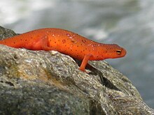
[3] Reptile species such as the eastern copperhead, timber rattlesnakes, watersnakes, box turtles and Amphibians such as frogs, toads, newts and salamanders are also common.
Spring and summer bring a riot of colorful blooms to many shrubs, vines, and herbaceous plants, ranging from the brilliant orange of flame azalea, the pink blooming mountain azalea and gorge rhododendron, to the pink lady's-slipper, yellow lady's-slipper, the blue cohosh, and the scarlet cardinal flower.
[7] The Cohutta Mountains, particularly the eastern region and the Potato Patch-Grassy-Bald Escarpment in the southwestern section, comprise one of the rainiest areas in Georgia due to its orographic lift.
The north-facing coves in this region receive over 80 inches of annual rainfall fostering some of the southernmost Appalachian temperate rainforests which are characterized by a thick, dense, and lush herbaceous layer of plants.
Extensive clearcutting and timber harvesting, particularly of the region's old-growth American chestnut, poplar, hemlock, and pine forests, continued until the 1930s when the Great Depression brought operations to a halt.
Today, much of the forest has reclaimed these summits, though similar grassy balds in regions like the Great Smoky Mountains and Roan Highlands are actively maintained by federal agencies.
Due to its popularity, with more than 60,000 visitors annually, the Forest Service has implemented regulations to mitigate overuse, including group size limits and restrictions on campfires.
The wilderness's rich cultural history, coupled with its ecological significance, makes it a critical area for both preservation and recreation.
This flat, grassy area atop the mountain was likely used as a ceremonial and recreational space where the Cherokee played Anetsa, a traditional stickball game often referred to as "the little brother of war".
[15] The Cohutta Wilderness and surrounding area is a haven for hikers, fishermen, botanists, kayakers, mountain bikers, naturalists, and hunters, offering a variety of ecosystems that traverse remote gorges, ridgelines, river valleys, and hardwood forests.
[16] Originally, the southern terminus of the Appalachian Trail was planned to run through the wilderness and end on Cohutta Mountain in Murray County, Georgia but was moved more south due to the area's remoteness.
The Cohutta Wilderness offers an extensive network of trails maintained by volunteers catering to hikers and backpackers of varying skill levels.
The trailhead parking lots affected by winter road closures are Tearbritches, Chestnut Lead, Betty Gap and Three Forks.